Framed Print > North America > United States of America > New York > New York > Maps
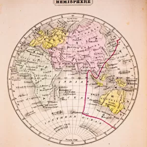
Framed Print : Eastern hemisphere map 1881


![]()
Framed Photos from Fine Art Storehouse
Eastern hemisphere map 1881
Harpers School Geography, New York, Harpers and Brothers, 1881
Unleash your creativity and transform your space into a visual masterpiece!
THEPALMER
Media ID 14756082
© This content is subject to copyright
Australia Eastern Hemisphere Indian Ocean Pacific Ocean World Hemispheres
12"x10" Modern Frame
Step back in time with our exquisite framed print of the Eastern Hemisphere Map from 1881, a captivating piece from THEPALMER's collection at Media Storehouse. Originally published by Harpers and Brothers, New York, in Harpers School Geography, this vintage map offers a fascinating glimpse into the historical geography of the Eastern Hemisphere. The intricate details and vibrant colors are beautifully preserved in this high-quality framed print, making it an exceptional addition to any home or office. Transport yourself to a bygone era with this stunning and educational piece of fine art.
10x8 Print in an MDF Wooden Frame with 180 gsm Satin Finish Paper. Glazed using shatter proof thin plexi glass. Frame thickness is 1 inch and depth 0.75 inch. Fluted cardboard backing held with clips. Supplied ready to hang with sawtooth hanger and rubber bumpers. Spot clean with a damp cloth. Packaged foam wrapped in a card.
Contemporary Framed and Mounted Prints - Professionally Made and Ready to Hang
Estimated Image Size (if not cropped) is 25.4cm x 25.4cm (10" x 10")
Estimated Product Size is 25.4cm x 30.5cm (10" x 12")
These are individually made so all sizes are approximate
Artwork printed orientated as per the preview above, with landscape (horizontal) or portrait (vertical) orientation to match the source image.
FEATURES IN THESE COLLECTIONS
> Fine Art Storehouse
> Map
> Historical Maps
> Africa
> Related Images
> Arts
> Artists
> I
> Indian School Indian School
> Arts
> Artists
> O
> Oceanic Oceanic
> Asia
> Related Images
> Maps and Charts
> Related Images
> Maps and Charts
> World
> North America
> United States of America
> New York
> New York
> Maps
> North America
> United States of America
> New York
> Related Images
EDITORS COMMENTS
This print showcases an exquisite piece of history, the "Eastern Hemisphere Map 1881". Originally featured in Harpers School Geography, New York, this masterpiece was published by Harpers and Brothers back in 1881. The intricate details and artistry displayed on this map are truly remarkable. The map encompasses a vast area spanning from Africa to Asia, Australia to Europe, with the Indian Ocean and Pacific Ocean beautifully depicted. It offers a glimpse into the world as it was perceived over a century ago. Every contour of landmasses and every delicate line marking borders tells a story of exploration and discovery. "The Eastern Hemisphere Map 1881" is not just an ordinary cartographic representation; it is a testament to human curiosity about our planet's diverse cultures and geography. As we gaze upon this vintage treasure captured by THEPALMER for Fine Art Storehouse, we can't help but feel transported back in time. The sepia-toned hues add depth to the image while preserving its authentic charm. This stunning print would make an exceptional addition to any home or office decor, evoking a sense of nostalgia for those who appreciate both history and art. Whether you are an avid collector or simply fascinated by the wonders of our world's past, "Eastern Hemisphere Map 1881" will undoubtedly captivate your imagination as you explore the intricacies that lie within its borders.
MADE IN THE USA
Safe Shipping with 30 Day Money Back Guarantee
FREE PERSONALISATION*
We are proud to offer a range of customisation features including Personalised Captions, Color Filters and Picture Zoom Tools
SECURE PAYMENTS
We happily accept a wide range of payment options so you can pay for the things you need in the way that is most convenient for you
* Options may vary by product and licensing agreement. Zoomed Pictures can be adjusted in the Cart.