Framed Print > Maps and Charts > Americas
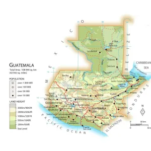
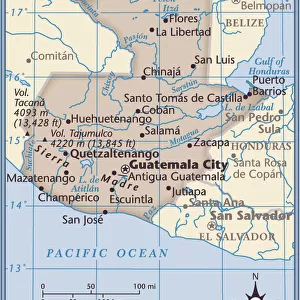
Framed Print : Guatemala and Honduras map 1883


![]()
Framed Photos from Fine Art Storehouse
Guatemala and Honduras map 1883
Encyclopedia Britannica 9th Edition New York Samuel L. Hall 1883 Vol XI
Unleash your creativity and transform your space into a visual masterpiece!
THEPALMER
Media ID 14756802
© This content is subject to copyright
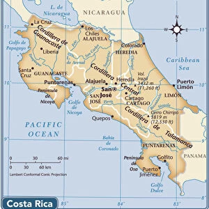
Central America Costa Rica Guatemala Honduras Nicaragua
12"x10" Modern Frame
Step back in time with our exquisite 'Guatemala and Honduras Map 1883' framed print from ThePalmer collection at Media Storehouse. This captivating map, taken from the Encyclopedia Britannica 9th Edition published in New York by Samuel L. Hall in 1883, offers a fascinating glimpse into the history and geography of Central America. Meticulously preserved and presented in a stylish frame, this vintage map adds a touch of historical charm and academic elegance to any room. Bring a piece of the past into your home or office today with our Guatemala and Honduras Map 1883 framed print.
10x8 Print in an MDF Wooden Frame with 180 gsm Satin Finish Paper. Glazed using shatter proof thin plexi glass. Frame thickness is 1 inch and depth 0.75 inch. Fluted cardboard backing held with clips. Supplied ready to hang with sawtooth hanger and rubber bumpers. Spot clean with a damp cloth. Packaged foam wrapped in a card.
Contemporary Framed and Mounted Prints - Professionally Made and Ready to Hang
Estimated Image Size (if not cropped) is 25.4cm x 25.4cm (10" x 10")
Estimated Product Size is 25.4cm x 30.5cm (10" x 12")
These are individually made so all sizes are approximate
Artwork printed orientated as per the preview above, with landscape (horizontal) or portrait (vertical) orientation to match the source image.
FEATURES IN THESE COLLECTIONS
> Fine Art Storehouse
> Map
> Historical Maps
> Maps and Charts
> Related Images
> North America
> Costa Rica
> Maps
> North America
> Costa Rica
> Related Images
> North America
> Guatemala
> Maps
> North America
> Guatemala
> Related Images
> North America
> Honduras
> Maps
> North America
> Honduras
> Related Images
> North America
> Nicaragua
> Maps
> North America
> Nicaragua
> Related Images
EDITORS COMMENTS
In this print titled "Guatemala and Honduras map 1883" we are transported back in time to the late 19th century. The image showcases a beautifully detailed map from the Encyclopedia Britannica's 9th Edition, published in New York by Samuel L. Hall in 1883. The map itself is a testament to the artistry and craftsmanship of cartographers during that era. With intricate lines, delicate lettering, and vibrant colors, it depicts Central America with an astonishing level of accuracy for its time. From Costa Rica to Guatemala, Honduras to Nicaragua, every border and coastline is meticulously outlined. This particular piece captures not only the geographical features but also provides us with a glimpse into history. It serves as a reminder of how our understanding of these regions has evolved over time while highlighting their rich cultural heritage. "ThePALMER" has skillfully preserved this historical gem through photography, allowing us to appreciate its beauty and significance today. As we gaze upon this artwork, we can't help but marvel at the dedication put forth by those who created such maps centuries ago. Whether you're an avid historian or simply captivated by vintage aesthetics, this print offers a unique opportunity to own a piece of history – one that tells stories of exploration, discovery, and the ever-changing world around us.
MADE IN THE USA
Safe Shipping with 30 Day Money Back Guarantee
FREE PERSONALISATION*
We are proud to offer a range of customisation features including Personalised Captions, Color Filters and Picture Zoom Tools
SECURE PAYMENTS
We happily accept a wide range of payment options so you can pay for the things you need in the way that is most convenient for you
* Options may vary by product and licensing agreement. Zoomed Pictures can be adjusted in the Cart.