Framed Print > North America > Haiti > Maps
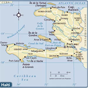
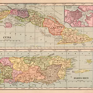
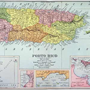
Framed Print : Haiti Puerto Rico map 1896


![]()
Framed Photos from Fine Art Storehouse
Haiti Puerto Rico map 1896
Andres Allgemeiner Handatlas - Bielefeld und Leipzig 1896
Unleash your creativity and transform your space into a visual masterpiece!
THEPALMER
Media ID 18357023
18"x14" Modern Frame
Discover the rich history of the Caribbean with our stunning Framed Print of the Haiti Puerto Rico Map from THEPALMER's Andres Allgemeiner Handatlas, published in 1896. This intricately detailed map transports you back in time, providing a captivating visual representation of the geography and political boundaries of Haiti and Puerto Rico during a pivotal era. The high-quality print is beautifully framed, adding an elegant touch to any room while showcasing your appreciation for historical cartography. Bring a piece of the past into your home or office today with this exquisite Framed Print from the Media Storehouse Fine Art collection.
16x12 Print in an MDF Wooden Frame with 180 gsm Satin Finish Paper. Glazed using shatter proof thin plexiglass. Frame thickness is 1 inch and depth 0.75 inch. Fluted cardboard backing held with clips. Supplied ready to hang with sawtooth hanger and rubber bumpers. Spot clean with a damp cloth. Packaged foam wrapped in a card.
Contemporary Framed and Mounted Prints - Professionally Made and Ready to Hang
Estimated Image Size (if not cropped) is 40.6cm x 35.6cm (16" x 14")
Estimated Product Size is 45.7cm x 35.6cm (18" x 14")
These are individually made so all sizes are approximate
Artwork printed orientated as per the preview above, with landscape (horizontal) orientation to match the source image.
FEATURES IN THESE COLLECTIONS
> Fine Art Storehouse
> Map
> Historical Maps
> Maps and Charts
> Related Images
> North America
> Haiti
> Maps
> North America
> Haiti
> Related Images
> North America
> Puerto Rico
> Maps
> North America
> Puerto Rico
> Related Images
EDITORS COMMENTS
This print showcases a historical gem - the Haiti Puerto Rico map from 1896, sourced from Andres Allgemeiner Handatlas. A true testament to the intricate artistry of cartography, this vintage piece takes us back in time to an era when maps were meticulously hand-drawn and beautifully detailed. The map itself is a fascinating fusion of geography and history, offering a glimpse into the past boundaries and topographical features of both Haiti and Puerto Rico. With its delicate lines and carefully shaded regions, it not only serves as a navigational tool but also as an artistic masterpiece that captures the essence of these Caribbean islands. As we admire this print by THEPALMER, we are reminded of how far we have come in terms of technological advancements in mapping techniques. Yet, there is an undeniable charm in witnessing the craftsmanship involved in creating such intricate maps manually. Whether you are a history enthusiast or simply appreciate fine art, this print allows you to immerse yourself in the rich cultural heritage of Haiti and Puerto Rico. It acts as a window into their pasts while simultaneously serving as an exquisite decorative piece for any space. With every glance at this remarkable artwork, one can't help but feel connected to these vibrant lands with their unique stories waiting to be explored.
MADE IN THE USA
Safe Shipping with 30 Day Money Back Guarantee
FREE PERSONALISATION*
We are proud to offer a range of customisation features including Personalised Captions, Color Filters and Picture Zoom Tools
SECURE PAYMENTS
We happily accept a wide range of payment options so you can pay for the things you need in the way that is most convenient for you
* Options may vary by product and licensing agreement. Zoomed Pictures can be adjusted in the Cart.