Framed Print > North America > United States of America > New York > New York > Maps
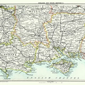
Framed Print : Map of Hampshire 1883


![]()
Framed Photos from Fine Art Storehouse
Map of Hampshire 1883
Encyclopedia Britannica 9th Edition New York Samuel L. Hall 1883 Vol XI
Unleash your creativity and transform your space into a visual masterpiece!
THEPALMER
Media ID 14549453
© This content is subject to copyright
12"x10" Modern Frame
Introducing the exquisite "Map of Hampshire 1883" framed print from Media Storehouse's Fine Art Storehouse collection. This stunning piece is a reproduction of an original map taken from the Encyclopedia Britannica 9th Edition, published in New York by Samuel L. Hall in 1883. The map, created by renowned cartographer THEPALMER, provides a captivating glimpse into the historical geography of Hampshire during this era. Each detail is meticulously rendered, making this framed print an exceptional addition to any home or office space. Transport yourself back in time with this beautiful piece of historical cartography.
10x8 Print in an MDF Wooden Frame with 180 gsm Satin Finish Paper. Glazed using shatter proof thin plexi glass. Frame thickness is 1 inch and depth 0.75 inch. Fluted cardboard backing held with clips. Supplied ready to hang with sawtooth hanger and rubber bumpers. Spot clean with a damp cloth. Packaged foam wrapped in a card.
Contemporary Framed and Mounted Prints - Professionally Made and Ready to Hang
Estimated Image Size (if not cropped) is 25.4cm x 25.4cm (10" x 10")
Estimated Product Size is 25.4cm x 30.5cm (10" x 12")
These are individually made so all sizes are approximate
Artwork printed orientated as per the preview above, with landscape (horizontal) or portrait (vertical) orientation to match the source image.
FEATURES IN THESE COLLECTIONS
> Fine Art Storehouse
> Map
> Historical Maps
> Europe
> United Kingdom
> England
> Hampshire
> Related Images
> Europe
> United Kingdom
> England
> Maps
> Europe
> United Kingdom
> England
> York
> Europe
> United Kingdom
> Maps
> Maps and Charts
> Related Images
> North America
> United States of America
> New York
> New York
> Maps
> North America
> United States of America
> New York
> Related Images
EDITORS COMMENTS
This print showcases a remarkable piece of history, the "Map of Hampshire 1883". Taken from the Encyclopedia Britannica's 9th Edition, this vintage map transports us back to a bygone era. Created in New York by Samuel L. Hall in 1883, it is an exquisite representation of Hampshire County in England. The intricate details and delicate craftsmanship captured within this print are truly awe-inspiring. Every contour and boundary line has been meticulously drawn, offering a glimpse into the geographical landscape as it existed over a century ago. The fine artistry displayed here is a testament to both the skill of its creator and the importance placed on cartography during that time. As we gaze upon this historical treasure, our imagination takes flight. We envision bustling towns and serene countryside scenes that once dotted this picturesque county. It serves as a reminder of how much has changed since then while also evoking nostalgia for simpler times. "The Map of Hampshire 1883" offers more than just geographic information; it encapsulates an entire era's spirit and charm within its inked lines. This print by THEPALMER allows us to bring home a piece of history and appreciate the beauty found in antique maps like never before.
MADE IN THE USA
Safe Shipping with 30 Day Money Back Guarantee
FREE PERSONALISATION*
We are proud to offer a range of customisation features including Personalised Captions, Color Filters and Picture Zoom Tools
SECURE PAYMENTS
We happily accept a wide range of payment options so you can pay for the things you need in the way that is most convenient for you
* Options may vary by product and licensing agreement. Zoomed Pictures can be adjusted in the Cart.