Framed Print > Arts > Artists > O > Oceanic Oceanic
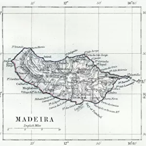
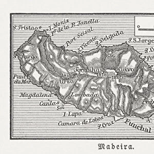
Framed Print : Map of Madeira, 19th Century


![]()
Framed Photos from Fine Art Storehouse
Map of Madeira, 19th Century
Vintage engraving of a Map of Madeira, 19th Century a Portuguese archipelago situated in the north Atlantic Ocean, southwest of Portugal
Unleash your creativity and transform your space into a visual masterpiece!
duncan1890
Media ID 15231359
© This content is subject to copyright
12"x10" Modern Frame
Step back in time with our exquisite Framed Print of "Map of Madeira, 19th Century" by duncan1890 from the Media Storehouse Fine Art Collection. This vintage engraving transports you to the historical charm of the Portuguese archipelago located in the north Atlantic Ocean, southwest of Portugal. Add an air of sophistication and nostalgia to your home or office decor with this beautifully framed, 19th-century map of Madeira. Each print is carefully inspected and framed with museum-quality materials to preserve the intricate details of the engraving. Order yours today and let history come alive in your space.
10x8 Print in an MDF Wooden Frame with 180 gsm Satin Finish Paper. Glazed using shatter proof thin plexi glass. Frame thickness is 1 inch and depth 0.75 inch. Fluted cardboard backing held with clips. Supplied ready to hang with sawtooth hanger and rubber bumpers. Spot clean with a damp cloth. Packaged foam wrapped in a card.
Contemporary Framed and Mounted Prints - Professionally Made and Ready to Hang
Estimated Image Size (if not cropped) is 25.4cm x 25.4cm (10" x 10")
Estimated Product Size is 30.5cm x 25.4cm (12" x 10")
These are individually made so all sizes are approximate
Artwork printed orientated as per the preview above, with landscape (horizontal) or portrait (vertical) orientation to match the source image.
FEATURES IN THESE COLLECTIONS
> Fine Art Storehouse
> Map
> Historical Maps
> Arts
> Artists
> O
> Oceanic Oceanic
> Europe
> Portugal
> Related Images
> Maps and Charts
> Related Images
EDITORS COMMENTS
This vintage engraving of a 19th-century Map of Madeira takes us on a journey back in time to explore the beauty and allure of this Portuguese archipelago. As we gaze upon this meticulously detailed print, we are transported to an era when cartography was both an art form and a scientific endeavor. The map showcases the enchanting islands that make up Madeira, situated in the vast expanse of the north Atlantic Ocean, southwest of Portugal. Each contour line and intricate illustration invites us to delve into its rich history and discover hidden treasures within its shores. With delicate strokes and exquisite craftsmanship, Duncan1890 has captured the essence of this island paradise. The faded hues evoke nostalgia while adding depth to every landmark depicted on the map. It is as if time itself has left its mark on this piece, reminding us that these islands have witnessed centuries of exploration and adventure. As we study each detail - from towering mountains to winding coastlines - our imagination begins to wander through lush forests, picturesque villages, and vibrant vineyards that dot the landscape. This artwork serves not only as a visual delight but also as an invitation for us to embark on our own voyage of discovery. Whether you are an avid collector or simply captivated by historical artifacts, this remarkable print from Fine Art Storehouse is sure to ignite your curiosity about Madeira's past. Let it transport you across oceans and continents as you immerse yourself in the timeless charm encapsulated within this 19th-century masterpiece.
MADE IN THE USA
Safe Shipping with 30 Day Money Back Guarantee
FREE PERSONALISATION*
We are proud to offer a range of customisation features including Personalised Captions, Color Filters and Picture Zoom Tools
SECURE PAYMENTS
We happily accept a wide range of payment options so you can pay for the things you need in the way that is most convenient for you
* Options may vary by product and licensing agreement. Zoomed Pictures can be adjusted in the Cart.