Framed Print > Oceania > Australia > Maps
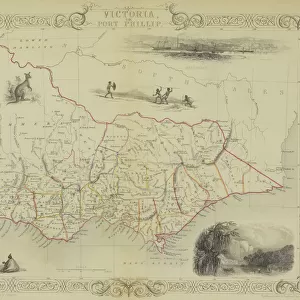
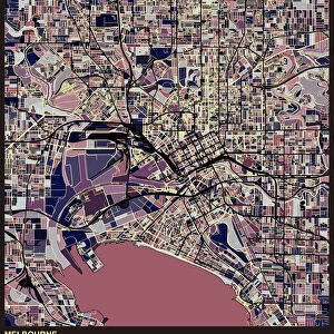
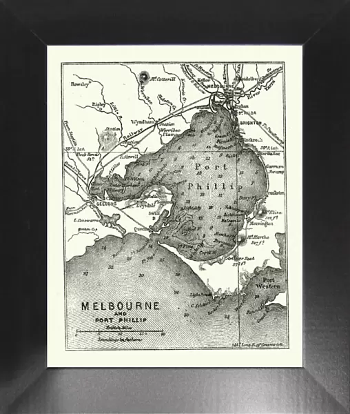
Framed Print : Map of Melbourne and Port Phillip, Australia, 19th Century


![]()
Framed Photos from Fine Art Storehouse
Map of Melbourne and Port Phillip, Australia, 19th Century
Vintage engraving of Map of Melbourne and Port Phillip, Australia, 19th Century
Unleash your creativity and transform your space into a visual masterpiece!
duncan1890
Media ID 18563408
© of Duncan P Walker
12"x10" Modern Frame
Step back in time with our exquisite Framed Print of "Map of Melbourne and Port Phillip, Australia, 19th Century" by duncan1890 from the Media Storehouse Fine Art collection. This stunning vintage engraving transports you to a bygone era with intricate details and accurate depictions of Melbourne and Port Phillip Bay during the 19th century. The rich historical significance of this map is beautifully preserved within the elegant frame, making it a captivating addition to any home or office. Bring a touch of history into your space with this timeless piece of art.
10x8 Print in an MDF Wooden Frame with 180 gsm Satin Finish Paper. Glazed using shatter proof thin plexi glass. Frame thickness is 1 inch and depth 0.75 inch. Fluted cardboard backing held with clips. Supplied ready to hang with sawtooth hanger and rubber bumpers. Spot clean with a damp cloth. Packaged foam wrapped in a card.
Contemporary Framed and Mounted Prints - Professionally Made and Ready to Hang
Estimated Image Size (if not cropped) is 25.4cm x 25.4cm (10" x 10")
Estimated Product Size is 25.4cm x 30.5cm (10" x 12")
These are individually made so all sizes are approximate
Artwork printed orientated as per the preview above, with landscape (horizontal) or portrait (vertical) orientation to match the source image.
FEATURES IN THESE COLLECTIONS
> Fine Art Storehouse
> Map
> Historical Maps
> Maps and Charts
> Related Images
> Oceania
> Australia
> Melbourne
> Oceania
> Australia
> Related Images
EDITORS COMMENTS
This vintage engraving takes us back to the 19th century, offering a glimpse into the historical charm of Melbourne and Port Phillip in Australia. The print showcases an intricately detailed map, meticulously crafted by Duncan1890. As we explore this piece, we are transported to a time when cartography was both an art form and a practical necessity. The Map of Melbourne and Port Phillip reveals the evolution of these regions during a pivotal era in Australian history. Every line on this antique artwork tells a story - from the bustling streets lined with horse-drawn carriages to the intricate network of waterways that connect Melbourne to its surrounding areas. As we study this mesmerizing print, our imagination runs wild with thoughts of what life might have been like for those who inhabited these lands centuries ago. We can almost hear the echoes of traders bartering their goods at bustling ports or envision families strolling through picturesque parks amidst Victorian-era architecture. Duncan1890's attention to detail is evident throughout every inch of this masterpiece, making it not only an exquisite work of art but also an invaluable historical artifact. This print serves as a reminder that our cities are built upon layers upon layers of stories waiting to be discovered. Whether you're an avid historian or simply captivated by the beauty found within vintage engravings, this Map of Melbourne and Port Phillip transports you back in time while igniting your curiosity about Australia's rich past.
MADE IN THE USA
Safe Shipping with 30 Day Money Back Guarantee
FREE PERSONALISATION*
We are proud to offer a range of customisation features including Personalised Captions, Color Filters and Picture Zoom Tools
SECURE PAYMENTS
We happily accept a wide range of payment options so you can pay for the things you need in the way that is most convenient for you
* Options may vary by product and licensing agreement. Zoomed Pictures can be adjusted in the Cart.