Framed Print > Maps and Charts > Related Images
Framed Print : Map of Middle East - illustration


Framed Photos from Fine Art Storehouse
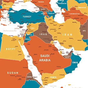
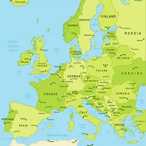
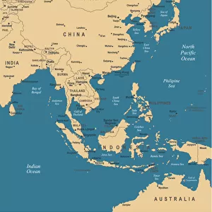
Map of Middle East - illustration
Colored Map of Middle East Asia with Country Names and Capital Cities
Unleash your creativity and transform your space into a visual masterpiece!
Media ID 13880193
12"x10" Modern Frame
Introducing the stunning "Map of Middle East - illustration" from our Fine Art Storehouse collection. This exquisite framed print showcases a vibrant and intricately detailed colored map of the Middle East, highlighting country names and capital cities. Transport yourself on a visual journey through this region's rich history and diverse cultures. Each print is carefully framed to preserve its beauty and enhance your decor, making it a perfect addition to any home or office space. Explore our range of sizes and find the perfect fit for your space today.
10x8 Print in an MDF Wooden Frame with 180 gsm Satin Finish Paper. Glazed using shatter proof thin plexi glass. Frame thickness is 1 inch and depth 0.75 inch. Fluted cardboard backing held with clips. Supplied ready to hang with sawtooth hanger and rubber bumpers. Spot clean with a damp cloth. Packaged foam wrapped in a card.
Contemporary Framed and Mounted Prints - Professionally Made and Ready to Hang
Estimated Image Size (if not cropped) is 25.4cm x 25.4cm (10" x 10")
Estimated Product Size is 25.4cm x 30.5cm (10" x 12")
These are individually made so all sizes are approximate
Artwork printed orientated as per the preview above, with landscape (horizontal) or portrait (vertical) orientation to match the source image.
FEATURES IN THESE COLLECTIONS
> Fine Art Storehouse
> Map
> Historical Maps
> Asia
> Related Images
> Maps and Charts
> Related Images
EDITORS COMMENTS
Vibrant Hues of the Middle East: A Colorful Journey through Countries and Capitals This and intricately detailed Map of the Middle East, with its rich hues and bold outlines, invites us on an enchanting exploration of the diverse lands and vibrant cultures that make up this fascinating region. The map, a beautiful illustration from the Fine Art Storehouse, showcases the Middle East in all its complexity, with each country represented in a distinct color and its capital city marked with a regal crown. From the sun-kissed shores of the Arabian Peninsula to the ancient lands of Iran and Iraq, the map transports us on a visual journey through the heart of the Middle East. The Sinai Peninsula, a bridge between Africa and Asia, is depicted in a warm, golden hue, while the verdant hills of Lebanon and Syria are rendered in lush greens. The arid expanses of the Empty Quarter in Arabia are contrasted by the irrigated oases that dot the region, creating a stunning tapestry of color and texture. Each capital city is marked with a regal crown, adding a touch of majesty to the map. The ancient city of Damascus, Syria, shines in a rich, red hue, while the modern metropolis of Dubai, United Arab Emirates, sparkles in gold. The map serves as a testament to the rich history and diverse cultures that have shaped the Middle East, making it an essential addition to any world map collection. This Map of the Middle East is not only a work of art but also an educational tool, providing a visual representation of the region's geography, borders, and political divisions. It is a must-have for anyone with a passion for travel, history, or geography, and a beautiful reminder of the vibrant and complex world we live in.
MADE IN THE USA
Safe Shipping with 30 Day Money Back Guarantee
FREE PERSONALISATION*
We are proud to offer a range of customisation features including Personalised Captions, Color Filters and Picture Zoom Tools
SECURE PAYMENTS
We happily accept a wide range of payment options so you can pay for the things you need in the way that is most convenient for you
* Options may vary by product and licensing agreement. Zoomed Pictures can be adjusted in the Cart.