Framed Print > Europe > Germany > Maps
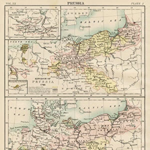
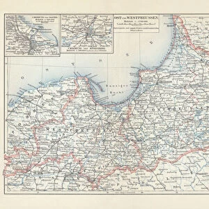
Framed Print : Map of Prussia (Germany), 1866 to 1918, litograph, published 1897
, 1866 to 1918, litograph, published 1897")
, 1866 to 1918, litograph, published 1897")

![]()
Framed Photos from Fine Art Storehouse
Map of Prussia (Germany), 1866 to 1918, litograph, published 1897
Map of the Prussian state in the German Empire with the largest expansion from 1866 to 1918. Lithograph, published in 1897
Unleash your creativity and transform your space into a visual masterpiece!
ZU_09
Media ID 18292259
18"x14" Modern Frame
Step back in time with our exquisite Framed Print of a historical map of Prussia, published in 1897. This captivating lithograph showcases the expansion of Prussia in Germany from 1866 to 1918. Add an element of history and sophistication to your space with this intricately detailed and authentic reproduction. The perfect addition to any home office, library, or study. Experience the rich heritage of the past with Media Storehouse's Fine Art Storehouse.
16x12 Print in an MDF Wooden Frame with 180 gsm Satin Finish Paper. Glazed using shatter proof thin plexiglass. Frame thickness is 1 inch and depth 0.75 inch. Fluted cardboard backing held with clips. Supplied ready to hang with sawtooth hanger and rubber bumpers. Spot clean with a damp cloth. Packaged foam wrapped in a card.
Contemporary Framed and Mounted Prints - Professionally Made and Ready to Hang
Estimated Image Size (if not cropped) is 40.6cm x 35.6cm (16" x 14")
Estimated Product Size is 45.7cm x 35.6cm (18" x 14")
These are individually made so all sizes are approximate
Artwork printed orientated as per the preview above, with landscape (horizontal) orientation to match the source image.
FEATURES IN THESE COLLECTIONS
> Fine Art Storehouse
> Map
> Historical Maps
> Maps and Charts
> Related Images
EDITORS COMMENTS
This lithograph, titled "Map of Prussia (Germany), 1866 to 1918" takes us on a historical journey through the expansion and transformation of the Prussian state within the German Empire. Published in 1897 by ZU_09, this print offers a visual representation of one of Europe's most influential territories during a crucial period. The map showcases Prussia's remarkable growth from 1866 to 1918, capturing its territorial acquisitions and political developments. With intricate details and precise cartographic work, it provides an invaluable resource for historians and enthusiasts alike. As we delve into this artwork, our eyes are drawn to the vibrant colors that highlight each region within Prussia. The shades vary from deep blues representing established territories to lighter hues indicating newly acquired lands. This chromatic distinction emphasizes both continuity and change throughout these significant years. Beyond its aesthetic appeal, this lithograph serves as a testament to the power dynamics that shaped European history during the late nineteenth century. It invites us to reflect upon how geopolitical forces influenced borders and alliances in an era marked by rapid industrialization and shifting national identities. Whether displayed in a classroom or cherished as part of a personal collection, this print is not only visually striking but also intellectually stimulating. It encapsulates an important chapter in Germany's past while offering endless opportunities for exploration and discussion about political geography, historical context, and cultural heritage.
MADE IN THE USA
Safe Shipping with 30 Day Money Back Guarantee
FREE PERSONALISATION*
We are proud to offer a range of customisation features including Personalised Captions, Color Filters and Picture Zoom Tools
SECURE PAYMENTS
We happily accept a wide range of payment options so you can pay for the things you need in the way that is most convenient for you
* Options may vary by product and licensing agreement. Zoomed Pictures can be adjusted in the Cart.