Framed Print > Europe > United Kingdom > Scotland > Maps
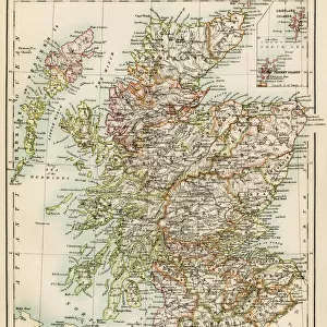
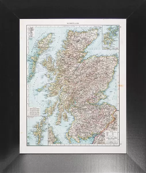
Framed Print : Map of Scotland 1896


![]()
Framed Photos from Fine Art Storehouse
Map of Scotland 1896
Andres Allgemeiner Handatlas - Bielefeld und Leipzig 1896
Unleash your creativity and transform your space into a visual masterpiece!
THEPALMER
Media ID 18356927
12"x10" Modern Frame
Step back in time with our exquisite Framed Print of "Map of Scotland 1896" from ThePalmer, part of our Media Storehouse Fine Art collection. This intricately detailed map, originally published in Andres Allgemeiner Handatlas in 1896, offers a captivating glimpse into Scotland's history. The vintage cartography, with its distinctive colors and borders, is a beautiful addition to any home or office. Our high-quality framing enhances the map's charm, preserving its antique character while ensuring durability. Bring a piece of historical cartography into your space and transport yourself to a bygone era.
10x8 Print in an MDF Wooden Frame with 180 gsm Satin Finish Paper. Glazed using shatter proof thin plexi glass. Frame thickness is 1 inch and depth 0.75 inch. Fluted cardboard backing held with clips. Supplied ready to hang with sawtooth hanger and rubber bumpers. Spot clean with a damp cloth. Packaged foam wrapped in a card.
Contemporary Framed and Mounted Prints - Professionally Made and Ready to Hang
Estimated Image Size (if not cropped) is 25.4cm x 25.4cm (10" x 10")
Estimated Product Size is 25.4cm x 30.5cm (10" x 12")
These are individually made so all sizes are approximate
Artwork printed orientated as per the preview above, with landscape (horizontal) or portrait (vertical) orientation to match the source image.
FEATURES IN THESE COLLECTIONS
> Fine Art Storehouse
> Map
> Historical Maps
> Europe
> United Kingdom
> Scotland
> Maps
> Europe
> United Kingdom
> Scotland
> Posters
> Europe
> United Kingdom
> Scotland
> Related Images
> Maps and Charts
> Related Images
EDITORS COMMENTS
This print showcases a remarkable piece of history, the "Map of Scotland 1896" from Andres Allgemeiner Handatlas. Transporting us back to the late 19th century, this meticulously detailed map offers a glimpse into Scotland's past with its intricate cartography and enchanting vintage aesthetic. The map, published in Bielefeld und Leipzig in 1896, takes us on an immersive journey through the rugged landscapes and charming towns that define this beautiful country. From the majestic peaks of the Highlands to the picturesque lochs dotting its surface, every corner of Scotland is intricately depicted on this historic artifact. As we explore closer, we can appreciate THEPALMER's expert craftsmanship in capturing every minute detail and preserving it for generations to come. The rich colors and fine lines bring life to each region, allowing us to imagine what life was like during that era. Whether you have Scottish roots or simply admire historical maps as works of art, this print is sure to captivate your imagination. It serves as a reminder of how our world has evolved over time while also celebrating the timeless beauty found within these ancient lands. Displaying "Map of Scotland 1896 (Andres Allgemeiner Handatlas - Bielefeld und Leipzig 1896)" by THEPALMER proudly on your wall will not only add a touch of elegance but also spark conversations about history and geography among friends and family.
MADE IN THE USA
Safe Shipping with 30 Day Money Back Guarantee
FREE PERSONALISATION*
We are proud to offer a range of customisation features including Personalised Captions, Color Filters and Picture Zoom Tools
SECURE PAYMENTS
We happily accept a wide range of payment options so you can pay for the things you need in the way that is most convenient for you
* Options may vary by product and licensing agreement. Zoomed Pictures can be adjusted in the Cart.