Framed Print > Africa > Guinea > Maps
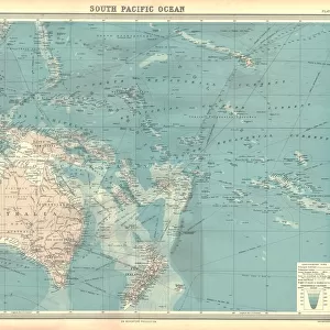
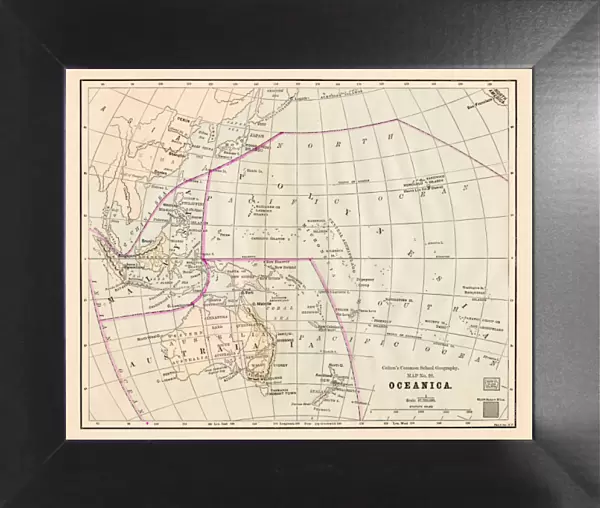
Framed Print : Oceania Australia map 1881


![]()
Framed Photos from Fine Art Storehouse
Oceania Australia map 1881
Coltons Common School Geography 1881 New York Sheldon and Co
Unleash your creativity and transform your space into a visual masterpiece!
THEPALMER
Media ID 13711459
© This content is subject to copyright
Atlas Mythological Figure Australasia Australia Globe Navigational Equipment Indonesia King Royal Person Malaysia New Zealand Pacific Ocean Paper Papua New Guinea Planet Earth Solomon Tasmania World Map
12"x10" Modern Frame
Step back in time with our exquisite Framed Print of "Oceania Australia Map 1881" from ThePalmer, available at Media Storehouse. This vintage map, hailing from Colton's Common School Geography published by Sheldon and Co in New York in 1881, adds an authentic touch of history to any room. The intricate details of the map are beautifully preserved in this high-quality framed print, making it a unique and captivating addition to your decor. Travel back to a time of exploration and discovery with this fascinating piece of cartographic history.
10x8 Print in an MDF Wooden Frame with 180 gsm Satin Finish Paper. Glazed using shatter proof thin plexi glass. Frame thickness is 1 inch and depth 0.75 inch. Fluted cardboard backing held with clips. Supplied ready to hang with sawtooth hanger and rubber bumpers. Spot clean with a damp cloth. Packaged foam wrapped in a card.
Contemporary Framed and Mounted Prints - Professionally Made and Ready to Hang
Estimated Image Size (if not cropped) is 25.4cm x 25.4cm (10" x 10")
Estimated Product Size is 30.5cm x 25.4cm (12" x 10")
These are individually made so all sizes are approximate
Artwork printed orientated as per the preview above, with landscape (horizontal) or portrait (vertical) orientation to match the source image.
FEATURES IN THESE COLLECTIONS
> Fine Art Storehouse
> Map
> Historical Maps
> Arts
> Artists
> O
> Oceanic Oceanic
> Asia
> Indonesia
> Related Images
> Asia
> Malaysia
> Related Images
> Maps and Charts
> Related Images
> Maps and Charts
> World
> North America
> United States of America
> Maps
EDITORS COMMENTS
This print titled "Oceania Australia map 1881" takes us back in time to the late 19th century when cartography was a blend of art and science. The image showcases an antique map from Coltons Common School Geography, published by Sheldon and Co in New York. The intricately engraved illustration depicts the vast expanse of Oceania, including Indonesia, Malaysia, USA, Australasia, New Zealand, Australia, Tasmania, Papua New Guinea and other surrounding islands. The attention to detail is remarkable as it highlights physical geography features such as the Pacific Ocean and various navigational equipment used during that era. What makes this piece truly special is its historical significance. It offers a glimpse into how people perceived the world at that time with mythological figures adorning the borders alongside royal personifications. This engraving serves as a testament to both human curiosity about our planet Earth and their artistic expression through cartography. Printed on old paper with an authentic feel, this artwork transports us back to an age where exploration was still ongoing and maps were cherished possessions for adventurers. "Oceania Australia map 1881" by THEPALMER is not just a beautiful decorative piece but also a window into our past – reminding us of the ever-evolving nature of our understanding of the world around us.
MADE IN THE USA
Safe Shipping with 30 Day Money Back Guarantee
FREE PERSONALISATION*
We are proud to offer a range of customisation features including Personalised Captions, Color Filters and Picture Zoom Tools
SECURE PAYMENTS
We happily accept a wide range of payment options so you can pay for the things you need in the way that is most convenient for you
* Options may vary by product and licensing agreement. Zoomed Pictures can be adjusted in the Cart.