Framed Print > Arts > Artists > O > Oceanic Oceanic
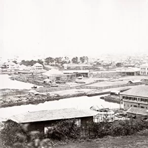
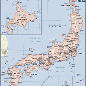
Framed Print : Old map of Yokohama, Japan, wood engraving, published in 1897


![]()
Framed Photos from Fine Art Storehouse
Old map of Yokohama, Japan, wood engraving, published in 1897
Old map of Yokohama, Japan. Wood engraving, published in 1897
Unleash your creativity and transform your space into a visual masterpiece!
Media ID 15309464
© This content is subject to copyright
City Map East Asia Harbor Japan Japanese Culture Pacific Ocean Tokyo Yokohama Kanagawa
12"x10" Modern Frame
Step back in time with our exquisite Old Map of Yokohama, Japan from the Fine Art Storehouse. This beautifully preserved wood engraving, published in 1897, offers a captivating glimpse into the history of this vibrant city. The intricate details of the map reveal the layout of Yokohama's bustling harbor, streets, and landmarks as they appeared over a century ago. Housed in a stylish frame, this unique piece is not only an attractive addition to any wall, but also a fascinating conversation starter. Bring a touch of history into your home or office with our Old Map of Yokohama from the Media Storehouse Fine Art collection.
10x8 Print in an MDF Wooden Frame with 180 gsm Satin Finish Paper. Glazed using shatter proof thin plexi glass. Frame thickness is 1 inch and depth 0.75 inch. Fluted cardboard backing held with clips. Supplied ready to hang with sawtooth hanger and rubber bumpers. Spot clean with a damp cloth. Packaged foam wrapped in a card.
Contemporary Framed and Mounted Prints - Professionally Made and Ready to Hang
Estimated Image Size (if not cropped) is 25.4cm x 25.4cm (10" x 10")
Estimated Product Size is 25.4cm x 30.5cm (10" x 12")
These are individually made so all sizes are approximate
Artwork printed orientated as per the preview above, with landscape (horizontal) or portrait (vertical) orientation to match the source image.
FEATURES IN THESE COLLECTIONS
> Fine Art Storehouse
> Map
> Historical Maps
> Arts
> Artists
> O
> Oceanic Oceanic
> Asia
> Japan
> Related Images
> Maps and Charts
> Early Maps
> Maps and Charts
> Related Images
EDITORS COMMENTS
This print showcases an old map of Yokohama, Japan, dating back to 1897. Crafted through the meticulous technique of wood engraving, this antique piece offers a glimpse into the city's rich history and cultural significance. Yokohama, located in Kanagawa prefecture near Tokyo, has long been renowned for its vibrant Japanese culture and bustling harbor. The map beautifully depicts the city's intricate coastline along the Pacific Ocean, capturing its strategic position as a major port during the 19th century. As we delve into this vertical woodcut engraving, we are transported back in time to an era where modernity was beginning to shape Yokohama's landscape. The detailed streets and landmarks showcased on this ancient map provide a fascinating insight into how the city evolved over time. With every line etched onto paper by skilled hands over a century ago, this print serves as both a historical artifact and a work of art. Its presence invites us to appreciate not only Yokohama's past but also highlights our connection with those who came before us. Whether you are an avid collector or simply intrigued by Japanese history and East Asian culture, this remarkable print is sure to captivate your imagination while adding an air of antiquity to any space it graces.
MADE IN THE USA
Safe Shipping with 30 Day Money Back Guarantee
FREE PERSONALISATION*
We are proud to offer a range of customisation features including Personalised Captions, Color Filters and Picture Zoom Tools
SECURE PAYMENTS
We happily accept a wide range of payment options so you can pay for the things you need in the way that is most convenient for you
* Options may vary by product and licensing agreement. Zoomed Pictures can be adjusted in the Cart.