Framed Print > Arts > Modern art pieces
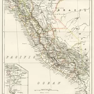
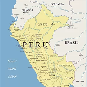
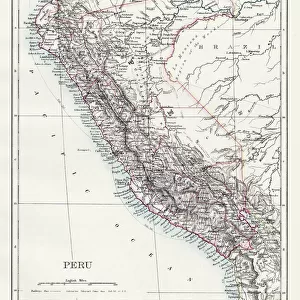
Framed Print : Peru map 1897


![]()
Framed Photos from Fine Art Storehouse
Peru map 1897
The World-Wide Atlas of Modern Geography, Political and Physical W. & A.K. Johnston - London 1897
Unleash your creativity and transform your space into a visual masterpiece!
THEPALMER
Media ID 14757116
© Roberto A Sanchez
Atlas Country Geographic Area Dictionary Earth Latin America Paper Peru South America Venezuela World Map Retro Styled
12"x10" Modern Frame
Introducing the captivating Peru Map 1897 Framed Print from Media Storehouse's Fine Art Storehouse collection. This exquisite piece showcases an intricately detailed map of Peru, hailing from The World-Wide Atlas of Modern Geography, Political and Physical W. & A.K. Johnston, published in London in 1897. The vintage cartography design is a delightful addition to any room, transporting you back in time with its rich history and intriguing details. The PERU Map 1897 Framed Print is meticulously crafted to preserve the original vintage aesthetic, allowing you to display a piece of historical cartography as a stunning work of art. Add this captivating piece to your home or office to ignite conversations and inspire a sense of adventure.
10x8 Print in an MDF Wooden Frame with 180 gsm Satin Finish Paper. Glazed using shatter proof thin plexi glass. Frame thickness is 1 inch and depth 0.75 inch. Fluted cardboard backing held with clips. Supplied ready to hang with sawtooth hanger and rubber bumpers. Spot clean with a damp cloth. Packaged foam wrapped in a card.
Contemporary Framed and Mounted Prints - Professionally Made and Ready to Hang
Estimated Image Size (if not cropped) is 25.4cm x 25.4cm (10" x 10")
Estimated Product Size is 25.4cm x 30.5cm (10" x 12")
These are individually made so all sizes are approximate
Artwork printed orientated as per the preview above, with landscape (horizontal) or portrait (vertical) orientation to match the source image.
FEATURES IN THESE COLLECTIONS
> Fine Art Storehouse
> Map
> Historical Maps
> Europe
> United Kingdom
> England
> London
> Politics
> Related Images
> Europe
> United Kingdom
> England
> London
> Related Images
> Maps and Charts
> Related Images
> Maps and Charts
> World
> South America
> Peru
> Maps
> South America
> Peru
> Related Images
> South America
> Related Images
EDITORS COMMENTS
This print takes us back in time to the year 1897, when cartography was a meticulous art form. The image showcases a vintage map of Peru, extracted from "The World-Wide Atlas of Modern Geography" by W. & A. K. Johnston - an esteemed publisher based in London during that era. With its retro-styled design and antique charm, this engraved image transports us to a world where paper maps were the ultimate guide for explorers and adventurers alike. The intricate details captured through engraving techniques bring forth the physical geography of Peru and its neighboring country Venezuela, both nestled within the vast continent of South America. As we gaze upon this piece, it is impossible not to appreciate the craftsmanship involved in creating such a work of art. Every contour and boundary on this map has been meticulously etched onto paper with precision and care. "The Palmer" an artist known for their passion for historical artifacts, has skillfully preserved this remarkable piece from yesteryears. This photograph serves as a testament to their dedication towards capturing moments frozen in time. Whether you are an avid collector or simply fascinated by history, this print offers more than just visual appeal; it provides a glimpse into how our understanding of Earth's geography has evolved over centuries. Let your imagination wander as you explore every inch of this enchanting Peruvian map from 1897 – truly an exquisite addition to any space!
MADE IN THE USA
Safe Shipping with 30 Day Money Back Guarantee
FREE PERSONALISATION*
We are proud to offer a range of customisation features including Personalised Captions, Color Filters and Picture Zoom Tools
SECURE PAYMENTS
We happily accept a wide range of payment options so you can pay for the things you need in the way that is most convenient for you
* Options may vary by product and licensing agreement. Zoomed Pictures can be adjusted in the Cart.