Framed Print > North America > United States of America > New York > New York > Maps
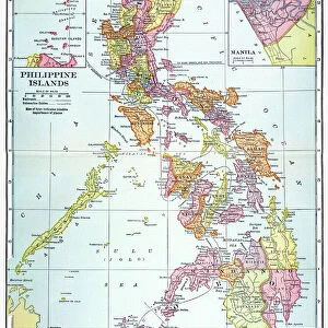
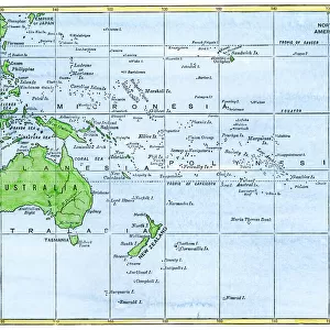
Framed Print : Philippines map 1885


![]()
Framed Photos from Fine Art Storehouse
Philippines map 1885
Encyclopedia Britannica 9th Edition New York Charles Scribners and Sons 1885 Vol XVIII
Unleash your creativity and transform your space into a visual masterpiece!
THEPALMER
Media ID 14756634
© This content is subject to copyright
Borneo Island Pacific Ocean Philippines Mindanao
12"x10" Modern Frame
Discover the rich history of the Philippines with our exquisite "Philippines Map 1885" Framed Print from ThePalmer at Media Storehouse. This captivating piece is taken from the Encyclopedia Britannica 9th Edition published by Charles Scribner's Sons in New York, 1885. This vintage map showcases intricate details and accurate representations of the Philippines during that era, making it a fascinating addition to any home or office space. The high-quality print is skillfully framed to preserve its beauty and authenticity, ensuring a timeless piece that adds character and depth to your decor. Bring a piece of history into your world with our "Philippines Map 1885" Framed Print from ThePalmer at Media Storehouse.
10x8 Print in an MDF Wooden Frame with 180 gsm Satin Finish Paper. Glazed using shatter proof thin plexi glass. Frame thickness is 1 inch and depth 0.75 inch. Fluted cardboard backing held with clips. Supplied ready to hang with sawtooth hanger and rubber bumpers. Spot clean with a damp cloth. Packaged foam wrapped in a card.
Contemporary Framed and Mounted Prints - Professionally Made and Ready to Hang
Estimated Image Size (if not cropped) is 25.4cm x 25.4cm (10" x 10")
Estimated Product Size is 25.4cm x 30.5cm (10" x 12")
These are individually made so all sizes are approximate
Artwork printed orientated as per the preview above, with landscape (horizontal) or portrait (vertical) orientation to match the source image.
FEATURES IN THESE COLLECTIONS
> Fine Art Storehouse
> Map
> Historical Maps
> Arts
> Artists
> O
> Oceanic Oceanic
> Asia
> Philippines
> Maps
> Asia
> Philippines
> Related Images
> Maps and Charts
> Related Images
> North America
> United States of America
> New York
> New York
> Maps
> North America
> United States of America
> New York
> Related Images
EDITORS COMMENTS
This print titled "Philippines map 1885" takes us on a journey back in time to the late 19th century. The image showcases an intricately detailed map of the Philippines, sourced from the esteemed Encyclopedia Britannica's 9th Edition published by Charles Scribners and Sons in New York in 1885. The map offers a glimpse into the geographical landscape of this archipelago nation, highlighting significant landmarks such as Borneo, Mindanao, and the vast Pacific Ocean that surrounds it. Its vintage charm is evident through its aged appearance and delicate lines that trace each island's contours. As we delve deeper into this historical artifact captured by THEPALMER, we are transported to an era when cartography was both artistry and science. This piece not only serves as a visual representation of Philippine geography but also acts as a window into cultural heritage and exploration during that period. With its rich hues and meticulous craftsmanship, this print from Fine Art Storehouse becomes more than just an aesthetic addition to any space; it becomes an educational tool bridging past and present. It invites viewers to appreciate the beauty of our world while igniting curiosity about how these lands have evolved over time. Whether displayed in homes or offices, this remarkable artwork sparks conversations about history, geography, and human progress – reminding us all of our interconnectedness with the past.
MADE IN THE USA
Safe Shipping with 30 Day Money Back Guarantee
FREE PERSONALISATION*
We are proud to offer a range of customisation features including Personalised Captions, Color Filters and Picture Zoom Tools
SECURE PAYMENTS
We happily accept a wide range of payment options so you can pay for the things you need in the way that is most convenient for you
* Options may vary by product and licensing agreement. Zoomed Pictures can be adjusted in the Cart.