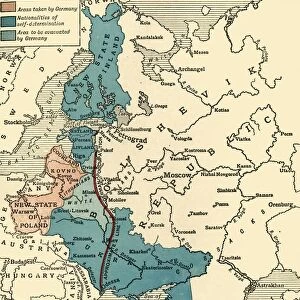
Framed Print > Asia > Related Images
Framed Print : Russian Siberia and Chinese Tartary 1846 Map


![]()
Framed Photos from Fine Art Storehouse
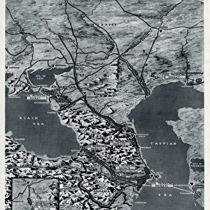
Russian Siberia and Chinese Tartary 1846 Map
Photo of an original map published in the Weekly Dispatch Atlas in 1846 in London
Unleash your creativity and transform your space into a visual masterpiece!
mashuk
Media ID 13667095
© mashuk
18th Century Direction East Asia Navigational Equipment Pacific Ocean Peninsula Publication Russia Siberia Topography
12"x10" Modern Frame
Discover the rich history of exploration with our stunning Framed Print of the "Russian Siberia and Chinese Tartary 1846 Map" from our Media Storehouse collection. This exquisite piece, inspired by the original map published in the Weekly Dispatch Atlas in London, transports you back in time to an era of intrigue and discovery. The intricate details of the map, showcasing the vast expanses of Russian Siberia and Chinese Tartary, are beautifully preserved in this high-quality print. The frame adds a touch of elegance and sophistication, making it a perfect addition to any home or office. Bring a piece of cartographic history into your space and ignite your imagination with this captivating Framed Print.
10x8 Print in an MDF Wooden Frame with 180 gsm Satin Finish Paper. Glazed using shatter proof thin plexi glass. Frame thickness is 1 inch and depth 0.75 inch. Fluted cardboard backing held with clips. Supplied ready to hang with sawtooth hanger and rubber bumpers. Spot clean with a damp cloth. Packaged foam wrapped in a card.
Contemporary Framed and Mounted Prints - Professionally Made and Ready to Hang
Estimated Image Size (if not cropped) is 25.4cm x 25.4cm (10" x 10")
Estimated Product Size is 30.5cm x 25.4cm (12" x 10")
These are individually made so all sizes are approximate
Artwork printed orientated as per the preview above, with landscape (horizontal) or portrait (vertical) orientation to match the source image.
FEATURES IN THESE COLLECTIONS
> Fine Art Storehouse
> Map
> Historical Maps
> Asia
> Related Images
> Europe
> Russia
> Related Images
> Europe
> United Kingdom
> England
> London
> Related Images
EDITORS COMMENTS
This print showcases a remarkable piece of cartography from the 19th century - the "Russian Siberia and Chinese Tartary 1846 Map". Originally published in London's Weekly Dispatch Atlas, this antique engraved image offers a glimpse into the rich history and topography of East Asia. The map is a true testament to the artistry and precision of 18th-century navigational equipment, as it meticulously outlines the vast expanse of Siberia, Russia, and the peninsula that stretches towards the Pacific Ocean. The vibrant colors used in this illustration bring life to every detail, making it an exquisite addition to any collection. As you explore this photo print, let your imagination wander back in time to when explorers relied on maps like these for their expeditions. Marvel at how they would have used such intricate depictions to navigate through uncharted territories. Whether you are an avid historian or simply appreciate fine art with historical significance, this horizontal image will undoubtedly captivate your attention. It serves as a visual portal into a bygone era while also showcasing the immense beauty found within cartographic masterpieces. Add depth and sophistication to your space with this stunning print by mashuk from Fine Art Storehouse. Let its presence transport you across continents and centuries as you admire its intricacies and ponder upon the journeys it represents.
MADE IN THE USA
Safe Shipping with 30 Day Money Back Guarantee
FREE PERSONALISATION*
We are proud to offer a range of customisation features including Personalised Captions, Color Filters and Picture Zoom Tools
SECURE PAYMENTS
We happily accept a wide range of payment options so you can pay for the things you need in the way that is most convenient for you
* Options may vary by product and licensing agreement. Zoomed Pictures can be adjusted in the Cart.