Framed Print > Fine Art Storehouse > Map
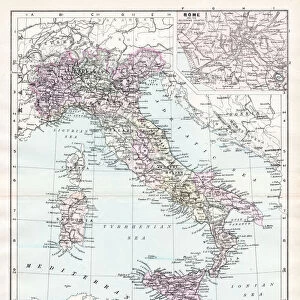
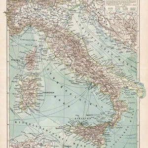
Framed Print : Map of Italy, lithograph, published in 1876


![]()
Framed Photos from Fine Art Storehouse
Map of Italy, lithograph, published in 1876
Map of Italy. Lithograph, published in 1876
Unleash your creativity and transform your space into a visual masterpiece!
Media ID 13666759
© ZU_09
Adriatic Sea Coastal Feature Contour Drawing Corsica European Culture Mediterranean Countries Mediterranean Culture Mediterranean Sea Sardinia Sicily Topographic Map Topography Tyrrhenian Sea Mediterran
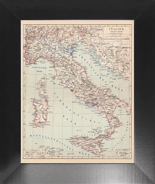
12"x10" Modern Frame
Step back in time with our exquisite Framed Prints from the Media Storehouse Fine Art Collection. This beautiful Map of Italy, a rare and authentic lithograph published in 1876, adds a touch of history and sophistication to any space. The intricate details of the map are preserved in stunning clarity, transporting you to the heart of Europe's cultural melting pot. Framed in a classic, understated design, this timeless piece is not only an attractive addition to your home or office, but also a conversation starter and a reminder of the rich history that lies within. Bring a piece of the past into your present with our Framed Prints from the Media Storehouse Fine Art Collection.
10x8 Print in an MDF Wooden Frame with 180 gsm Satin Finish Paper. Glazed using shatter proof thin plexi glass. Frame thickness is 1 inch and depth 0.75 inch. Fluted cardboard backing held with clips. Supplied ready to hang with sawtooth hanger and rubber bumpers. Spot clean with a damp cloth. Packaged foam wrapped in a card.
Contemporary Framed and Mounted Prints - Professionally Made and Ready to Hang
Estimated Image Size (if not cropped) is 25.4cm x 25.4cm (10" x 10")
Estimated Product Size is 25.4cm x 30.5cm (10" x 12")
These are individually made so all sizes are approximate
Artwork printed orientated as per the preview above, with landscape (horizontal) or portrait (vertical) orientation to match the source image.
FEATURES IN THESE COLLECTIONS
> Fine Art Storehouse
> Map
> Historical Maps
> Fine Art Storehouse
> Map
> Italian Maps
EDITORS COMMENTS
This lithograph, published in 1876, showcases a beautifully detailed Map of Italy. A true testament to the artistry of cartography, this antique engraved image takes us back in time to explore the rich topography and coastal features of this Mediterranean gem. The vertical composition allows for an immersive experience as we trace our fingers along the Tyrrhenian Sea's intricate coastline. The map highlights not only mainland Italy but also its neighboring islands such as Sardinia and Sicily. Corsica, with its close proximity to Italy, is also included in this comprehensive depiction of European geography. As we study the contours and intricacies of each region, it becomes evident that this lithograph serves as more than just a navigational tool; it offers a glimpse into ancient history and Mediterranean culture. The artist's attention to detail is remarkable - every contour drawing meticulously etched onto paper tells a story of centuries-old civilizations thriving along these shores. The vastness of the Mediterranean Sea dominates the scene, reminding us why Italy has been at the heart of European culture for millennia. Whether you are an enthusiast for historical maps or simply appreciate fine art photography from 2015 capturing such timeless beauty, this print will transport you through time and space without ever leaving your home.
MADE IN THE USA
Safe Shipping with 30 Day Money Back Guarantee
FREE PERSONALISATION*
We are proud to offer a range of customisation features including Personalised Captions, Color Filters and Picture Zoom Tools
SECURE PAYMENTS
We happily accept a wide range of payment options so you can pay for the things you need in the way that is most convenient for you
* Options may vary by product and licensing agreement. Zoomed Pictures can be adjusted in the Cart.