Framed Print > Asia > Turkey > Related Images
Framed Print : old map of europe


![]()
Framed Photos from Fine Art Storehouse
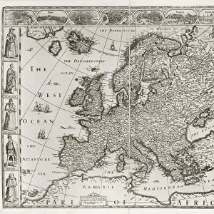
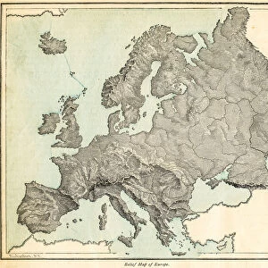
old map of europe
an old map form 1883, showing european countries
Unleash your creativity and transform your space into a visual masterpiece!
THEPALMER
Media ID 15134767
© Roberto A Sanchez
Austria Backgrounds Direction European Community Grunge Map02 Mediterranean Countries Mediterranean Sea National Border Paper Patina Retro Revival Rust Rusty Sepia Toned Textured Effect Torn Turkey Obsolete
12"x10" Modern Frame
Step back in time with our exquisite Framed Print of the Old Map of Europe from THEPALMER collection at Media Storehouse. This stunning piece, sourced from Fine Art Storehouse, transports you to an era long past with intricate detail and captivating accuracy. The map, originally published in 1883, showcases the European countries as they once were, a true masterpiece for history enthusiasts and art lovers alike. Frame your own slice of history and add a touch of timeless charm to your space.
10x8 Print in an MDF Wooden Frame with 180 gsm Satin Finish Paper. Glazed using shatter proof thin plexi glass. Frame thickness is 1 inch and depth 0.75 inch. Fluted cardboard backing held with clips. Supplied ready to hang with sawtooth hanger and rubber bumpers. Spot clean with a damp cloth. Packaged foam wrapped in a card.
Contemporary Framed and Mounted Prints - Professionally Made and Ready to Hang
Estimated Image Size (if not cropped) is 25.4cm x 25.4cm (10" x 10")
Estimated Product Size is 30.5cm x 25.4cm (12" x 10")
These are individually made so all sizes are approximate
Artwork printed orientated as per the preview above, with landscape (horizontal) or portrait (vertical) orientation to match the source image.
FEATURES IN THESE COLLECTIONS
> Fine Art Storehouse
> Map
> Historical Maps
> Fine Art Storehouse
> Map
> Italian Maps
> Asia
> Turkey
> Related Images
> Europe
> Austria
> Related Images
> Europe
> Italy
> Related Images
> Europe
> Related Images
EDITORS COMMENTS
This print titled "Old Map of Europe" takes us on a journey back in time to the year 1883. The image showcases a beautifully preserved map, revealing the European countries as they were over a century ago. With its intricate cartography and faded sepia tones, this piece exudes an air of retro revival and nostalgia. The map highlights the Mediterranean countries prominently, reminding us of their historical significance and cultural richness. Each national border is delicately drawn, reflecting the meticulous attention to detail that was characteristic of old-world cartographers. The physical geography is also depicted with textured effects, giving it an authentic feel. As we explore this vintage treasure further, we notice signs of age - rusty edges and torn corners - adding to its charm and authenticity. The paper itself bears witness to history's passage; it carries a patina that tells stories untold. From Turkey to Spain, Italy to Austria, France to England – all these nations are intricately woven together on this old map representing Europe's diverse tapestry. The Mediterranean Sea acts as both a unifying force and a gateway for trade and exploration throughout history. With its grunge aesthetic combined with elements of antiquity, this artwork by THEPALMER transports us into another era altogether. It serves as a reminder of how borders have shifted over time while celebrating our shared heritage rooted in European community.
MADE IN THE USA
Safe Shipping with 30 Day Money Back Guarantee
FREE PERSONALISATION*
We are proud to offer a range of customisation features including Personalised Captions, Color Filters and Picture Zoom Tools
SECURE PAYMENTS
We happily accept a wide range of payment options so you can pay for the things you need in the way that is most convenient for you
* Options may vary by product and licensing agreement. Zoomed Pictures can be adjusted in the Cart.