Framed Print > Maps and Charts > Related Images
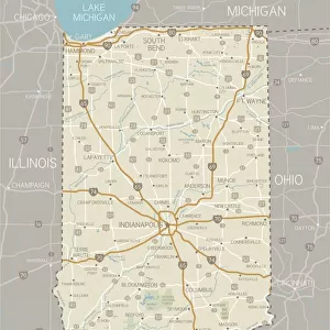
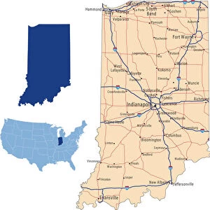
Framed Print : Indiana Highway Map


Framed Photos from Fine Art Storehouse
Indiana Highway Map
Reference Maps, Top Sellers Art Prints, 103312674
Unleash your creativity and transform your space into a visual masterpiece!
Media ID 14431831
12"x10" Modern Frame
Discover the captivating beauty of the open road with our "Indiana Highway Map" Framed Print from the Media Storehouse collection at Fine Art Storehouse. This stunning piece of art isn't just a map, it's a journey through the heart of America's Midwest. With intricate details and vibrant colors, this print brings the iconic Indiana highway system to life. Each print is carefully framed with a sleek and modern design, making it a perfect addition to any home or office. Travel the roads less traveled and bring a piece of the Hoosier State into your space. Order yours today and let the adventure begin! (Reference: Maps, Top Sellers Art Prints, 103312674)
10x8 Print in an MDF Wooden Frame with 180 gsm Satin Finish Paper. Glazed using shatter proof thin plexi glass. Frame thickness is 1 inch and depth 0.75 inch. Fluted cardboard backing held with clips. Supplied ready to hang with sawtooth hanger and rubber bumpers. Spot clean with a damp cloth. Packaged foam wrapped in a card.
Contemporary Framed and Mounted Prints - Professionally Made and Ready to Hang
Estimated Image Size (if not cropped) is 25.4cm x 25.4cm (10" x 10")
Estimated Product Size is 25.4cm x 30.5cm (10" x 12")
These are individually made so all sizes are approximate
Artwork printed orientated as per the preview above, with landscape (horizontal) or portrait (vertical) orientation to match the source image.
FEATURES IN THESE COLLECTIONS
> Fine Art Storehouse
> Map
> Reference Maps
> Fine Art Storehouse
> Top Sellers - Art Prints
> Maps and Charts
> Related Images
EDITORS COMMENTS
This print showcases the intricate beauty of an Indiana Highway Map. With its vibrant colors and detailed cartography, this art piece is a must-have for any map enthusiast or lover of fine art. The illustration depicts the state of Indiana in all its glory, highlighting its diverse landscapes and extensive road network. The artist's skillful use of vector graphics brings this map to life, creating a visually stunning representation that is both informative and aesthetically pleasing. Every town, city, and highway is meticulously rendered with precision and accuracy, making it an invaluable reference tool for travelers or those curious about the geography of Indiana. What makes this print truly remarkable is its ability to transport you into the heartland of America without ever leaving your home. As you gaze upon it, you can almost feel the open roads beckoning you on a journey through picturesque countryside and bustling cities. Whether displayed in a study room or as part of a gallery wall collection, this artwork adds sophistication and intellectual curiosity to any space. Its timeless appeal transcends generations, making it an ideal gift for history buffs or anyone with ties to Indiana.
MADE IN THE USA
Safe Shipping with 30 Day Money Back Guarantee
FREE PERSONALISATION*
We are proud to offer a range of customisation features including Personalised Captions, Color Filters and Picture Zoom Tools
SECURE PAYMENTS
We happily accept a wide range of payment options so you can pay for the things you need in the way that is most convenient for you
* Options may vary by product and licensing agreement. Zoomed Pictures can be adjusted in the Cart.