Framed Print > Aerial Photography > Related Images
Framed Print : Norman Oklahoma US City Street Map
![]()

Framed Photos from Fine Art Storehouse
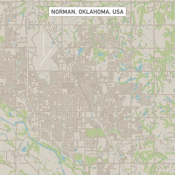
Norman Oklahoma US City Street Map
Vector Illustration of a City Street Map of Norman, Oklahoma, USA. Scale 1:60, 000.
All source data is in the public domain.
U.S. Geological Survey, US Topo
Used Layers:
USGS The National Map: National Hydrography Dataset (NHD)
USGS The National Map: National Transportation Dataset (NTD)
Unleash your creativity and transform your space into a visual masterpiece!
Frank Ramspott
Media ID 15215770
© Frank Ramspott, all rights reserved
Aerial View City Map Computer Graphic Directly Above Downtown District Gray Norman Oklahoma Road Map Text Digitally Generated Image Green Color White Color
12"x10" Modern Frame
Discover the charm of Norman, Oklahoma with our Framed Print of "Norman Oklahoma US City Street Map" by Frank Ramspott. This exquisite piece is a vector illustration of a City Street Map of Norman, USA, meticulously created with a scale of 1:60,000. With all source data in the public domain and proudly displaying the U.S. city's intricate details, this Framed Print is not only a functional addition to your space but also a beautiful work of art. Elevate your home or office décor with a touch of urban sophistication and nostalgia. Order your Framed Print of Norman Oklahoma US City Street Map today and let the adventure begin!
10x8 Print in an MDF Wooden Frame with 180 gsm Satin Finish Paper. Glazed using shatter proof thin plexi glass. Frame thickness is 1 inch and depth 0.75 inch. Fluted cardboard backing held with clips. Supplied ready to hang with sawtooth hanger and rubber bumpers. Spot clean with a damp cloth. Packaged foam wrapped in a card.
Contemporary Framed and Mounted Prints - Professionally Made and Ready to Hang
Estimated Image Size (if not cropped) is 25.4cm x 25.4cm (10" x 10")
Estimated Product Size is 25.4cm x 30.5cm (10" x 12")
These are individually made so all sizes are approximate
Artwork printed orientated as per the preview above, with landscape (horizontal) or portrait (vertical) orientation to match the source image.
FEATURES IN THESE COLLECTIONS
> Fine Art Storehouse
> Map
> Street Maps
> Fine Art Storehouse
> Map
> USA Maps
> Aerial Photography
> Related Images
> Animals
> Insects
> Hemiptera
> Green Scale
> Arts
> Contemporary art
> Digital artwork
> Street art
> Arts
> Street art graffiti
> Digital art
> Digital paintings
> Arts
> Street art graffiti
> Digital art
> Vector illustrations
> Maps and Charts
> Geological Map
> Maps and Charts
> Related Images
> North America
> United States of America
> Lakes
> Related Images
> North America
> United States of America
> Maps
> North America
> United States of America
> Oklahoma
> Oklahoma City
EDITORS COMMENTS
This print showcases a meticulously detailed vector illustration of the charming city street map of Norman, Oklahoma, USA. With a scale of 1:60,000, every intricate aspect is beautifully captured in this artwork. The artist, Frank Ramspott, skillfully utilized various layers from public domain sources such as the U. S. Geological Survey and US Topo to create this visually stunning piece. The image highlights key features including the downtown district, serene lake and river views, as well as an array of streets that intricately weave through the city's landscape. This digitally generated masterpiece offers a unique perspective with its aerial view directly above Norman. The color palette used in this artwork adds depth and vibrancy to the composition. Shades of gray and blue represent roads and water bodies respectively while white signifies open spaces. The lush green hues symbolize parks or natural areas within the city. With no people present in the image, all attention is drawn towards exploring each corner of this urban gem through cartography and design elements. This print serves not only as an aesthetically pleasing addition to any space but also provides valuable information about Norman's physical geography. Whether you are a resident or simply fascinated by maps and cities, this exceptional creation by Frank Ramspott invites you to embark on a visual journey through one of Oklahoma's most beloved towns - Norman!
MADE IN THE USA
Safe Shipping with 30 Day Money Back Guarantee
FREE PERSONALISATION*
We are proud to offer a range of customisation features including Personalised Captions, Color Filters and Picture Zoom Tools
SECURE PAYMENTS
We happily accept a wide range of payment options so you can pay for the things you need in the way that is most convenient for you
* Options may vary by product and licensing agreement. Zoomed Pictures can be adjusted in the Cart.


