Framed Print > Africa > Related Images
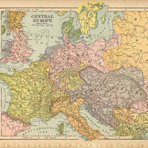
Framed Print : Speeds Map Of Europe


![]()
Framed Photos from Fine Art Storehouse
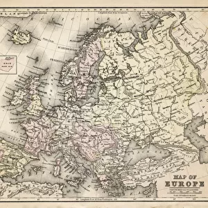
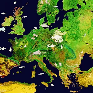
Speeds Map Of Europe
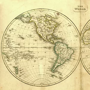
A map of Europe and the coast of North Africa by cartographer John Speed, 1626. Around the edges are insets of the major European cities and their inhabitants. (Photo by Hulton Archive/Getty Images)
Unleash your creativity and transform your space into a visual masterpiece!
Hulton Archive
Media ID 11809464
© 2008 Getty Images
12"x10" Modern Frame
Discover the rich history and culture of Europe with our stunning Framed Prints from Media Storehouse. This exquisite piece showcases the "Speeds Map Of Europe" by Hulton Archive from the Fine Art Storehouse. Dated back to 1626, this intricately detailed map by renowned cartographer John Speed, offers a captivating glimpse into Europe's past. With insets of major European cities and their inhabitants around the edges, this map is not just a geographical representation but also a time capsule of history. Add this beautiful Framed Print to your home or office and let the stories of Europe's past unfold before your eyes.
10x8 Print in an MDF Wooden Frame with 180 gsm Satin Finish Paper. Glazed using shatter proof thin plexi glass. Frame thickness is 1 inch and depth 0.75 inch. Fluted cardboard backing held with clips. Supplied ready to hang with sawtooth hanger and rubber bumpers. Spot clean with a damp cloth. Packaged foam wrapped in a card.
Contemporary Framed and Mounted Prints - Professionally Made and Ready to Hang
Estimated Image Size (if not cropped) is 25.4cm x 25.4cm (10" x 10")
Estimated Product Size is 30.5cm x 25.4cm (12" x 10")
These are individually made so all sizes are approximate
Artwork printed orientated as per the preview above, with landscape (horizontal) or portrait (vertical) orientation to match the source image.
FEATURES IN THESE COLLECTIONS
> Fine Art Storehouse
> Photo Libraries
> Heritage Images
> Africa
> Related Images
EDITORS COMMENTS
This print showcases John Speed's remarkable map of Europe and the coast of North Africa, dating back to 1626. The intricate details and exquisite craftsmanship make it a true masterpiece in cartography. As you gaze upon this historic artwork, you are transported to an era when exploration was at its peak. The map itself is surrounded by insets depicting major European cities and their inhabitants, offering a glimpse into the diverse cultures that thrived during that time. It is fascinating to observe how these cities have evolved over centuries, yet still retain their unique charm. The black sea stretches across the Atlantic Ocean and Mediterranean Sea, connecting different regions with its vastness. This visual representation reminds us of the significant role maritime trade played in shaping Europe's history. In this sepia-toned format, every line and contour tells a story of discovery and adventure. The landscape orientation allows for a comprehensive view of the continent's geographical features while emphasizing its vastness. As you examine this print closely, you can't help but wonder about the countless explorers who relied on maps like these as they embarked on perilous journeys through uncharted territories. It serves as a testament to human curiosity and our relentless pursuit of knowledge. Whether displayed in your home or office, this print from Fine Art Storehouse brings together artistry and historical significance in one frame. It captures not only an early depiction of Europe but also ignites our imagination about what lies beyond those borders - both geographically and culturally.
MADE IN THE USA
Safe Shipping with 30 Day Money Back Guarantee
FREE PERSONALISATION*
We are proud to offer a range of customisation features including Personalised Captions, Color Filters and Picture Zoom Tools
SECURE PAYMENTS
We happily accept a wide range of payment options so you can pay for the things you need in the way that is most convenient for you
* Options may vary by product and licensing agreement. Zoomed Pictures can be adjusted in the Cart.