Framed Print > North America > Jamaica > Maps
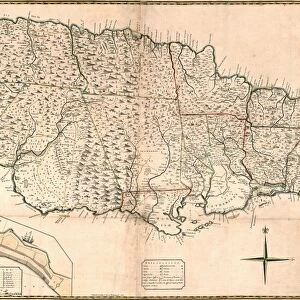
Framed Print : MAP: JAMAICA, 1893. British map of Jamaica by Colin Liddell, published 1893


Framed Photos from Granger
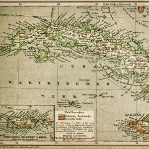
MAP: JAMAICA, 1893. British map of Jamaica by Colin Liddell, published 1893
MAP: JAMAICA, 1893.
British map of Jamaica by Colin Liddell, published 1893
Granger holds millions of images spanning more than 25,000 years of world history, from before the Stone Age to the dawn of the Space Age
Media ID 12321410
1893 British Colin Island Jamaica Liddell
18"x14" Modern Frame
Introducing the stunning addition to your decor from Media Storehouse's Framed Prints collection: a vintage, antique map of Jamaica from 1893. This exquisite piece, published by The Granger Collection in New York City, is an authentic reproduction of a British map created by Colin Liddell. Travel back in time with this captivating historical artifact, showcasing intricate detail and vibrant colors. Elevate the look of your home or office with this unique and educational framed print. Experience the charm of the past, brought to life in the present.
16x12 Print in an MDF Wooden Frame with 180 gsm Satin Finish Paper. Glazed using shatter proof thin plexiglass. Frame thickness is 1 inch and depth 0.75 inch. Fluted cardboard backing held with clips. Supplied ready to hang with sawtooth hanger and rubber bumpers. Spot clean with a damp cloth. Packaged foam wrapped in a card.
Contemporary Framed and Mounted Prints - Professionally Made and Ready to Hang
Estimated Image Size (if not cropped) is 40.6cm x 35.6cm (16" x 14")
Estimated Product Size is 45.7cm x 35.6cm (18" x 14")
These are individually made so all sizes are approximate
Artwork printed orientated as per the preview above, with landscape (horizontal) orientation to match the source image.
FEATURES IN THESE COLLECTIONS
> Maps and Charts
> Related Images
> North America
> Jamaica
> Maps
> North America
> Jamaica
> Related Images
> Granger Art on Demand
> Maps
EDITORS COMMENTS
This print showcases a remarkable piece of history - a British map of Jamaica from 1893. Created by the talented cartographer Colin Liddell, this intricately detailed engraving offers a glimpse into the island's past during the late 19th century. The map itself is a testament to Liddell's expertise and dedication, as every contour and feature of Jamaica is meticulously depicted. From its lush landscapes to its bustling towns and cities, this vintage map provides an invaluable snapshot of the island's geography at that time. As we delve into this historical artifact, we are transported back to an era when Jamaica was under British rule. The mid-1890s marked a significant period for the island nation as it navigated through various social, political, and economic changes. Through careful examination of this print, one can uncover hidden details embedded within its borders - perhaps discovering forgotten landmarks or tracing ancestral roots on this Caribbean gem. Granger Art on Demand has beautifully preserved this piece from their extensive collection in New York City. By offering us access to such rare artifacts like "MAP: JAMAICA, 1893" they allow us to connect with our shared heritage and gain deeper insights into our world's rich tapestry of cultures and histories.
MADE IN THE USA
Safe Shipping with 30 Day Money Back Guarantee
FREE PERSONALISATION*
We are proud to offer a range of customisation features including Personalised Captions, Color Filters and Picture Zoom Tools
SECURE PAYMENTS
We happily accept a wide range of payment options so you can pay for the things you need in the way that is most convenient for you
* Options may vary by product and licensing agreement. Zoomed Pictures can be adjusted in the Cart.