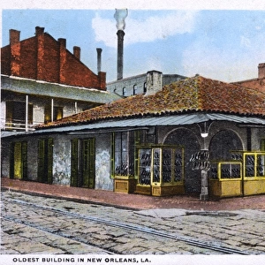
Framed Print > North America > United States of America > Louisiana > New Orleans
Framed Print : Plan of New Orleans, Louisiana, 1718-1720: engraving, French, 1753


![]()
Framed Photos from Granger
Plan of New Orleans, Louisiana, 1718-1720: engraving, French, 1753
NEW ORLEANS, 1718-1720.
Plan of New Orleans, Louisiana, 1718-1720: engraving, French, 1753
Granger holds millions of images spanning more than 25,000 years of world history, from before the Stone Age to the dawn of the Space Age
Media ID 10408642
1718 1719 1720 Colony New France New Orleans Plan Topography United States Southeast
12"x10" Modern Frame
Step back in time with our stunning Framed Print from Media Storehouse's collection, featuring the historical "Plan of New Orleans, Louisiana, 1718-1720: engraving, French, 1753" by Granger Art on Demand (140_1688650). This exquisite piece showcases an intricate and detailed depiction of New Orleans as it looked over 300 years ago. The intricate lines and shading of this engraving bring the history of this vibrant city to life. Hang it in your home or office as a conversation starter or a beautiful addition to your decor. Immerse yourself in the rich history of New Orleans with this captivating Framed Print.
10x8 Print in an MDF Wooden Frame with 180 gsm Satin Finish Paper. Glazed using shatter proof thin plexi glass. Frame thickness is 1 inch and depth 0.75 inch. Fluted cardboard backing held with clips. Supplied ready to hang with sawtooth hanger and rubber bumpers. Spot clean with a damp cloth. Packaged foam wrapped in a card.
Contemporary Framed and Mounted Prints - Professionally Made and Ready to Hang
Estimated Image Size (if not cropped) is 25.4cm x 25.4cm (10" x 10")
Estimated Product Size is 30.5cm x 25.4cm (12" x 10")
These are individually made so all sizes are approximate
Artwork printed orientated as per the preview above, with landscape (horizontal) or portrait (vertical) orientation to match the source image.
FEATURES IN THESE COLLECTIONS
> Arts
> Landscape paintings
> Waterfall and river artworks
> River artworks
> Maps and Charts
> Related Images
> North America
> United States of America
> Louisiana
> New Orleans
> South America
> Related Images
> Granger Art on Demand
> Plans and Diagrams
EDITORS COMMENTS
This print showcases the intricate "Plan of New Orleans, Louisiana" as it appeared between 1718 and 1720. Engraved by French artists in 1753, this historical map offers a fascinating glimpse into the early development of one of America's most iconic cities. The detailed engraving highlights the topography and layout of New Orleans during its formative years as a French colony. It vividly captures the city's strategic location along the Mississippi River, which played a crucial role in shaping its growth and prosperity. As we delve into this visual masterpiece, we are transported back to an era when New Orleans was known as "La Nouvelle-Orléans" part of France's vast colonial empire in North America. The plan reveals the careful urban planning that went into establishing streets, squares, and buildings that would shape the city's unique character for centuries to come. With its rich history and cultural heritage deeply rooted in both European and American influences, New Orleans stands as a testament to resilience and diversity. This remarkable engraving serves not only as a beautiful piece of art but also as a valuable historical document that allows us to appreciate how far this vibrant southern city has come since its humble beginnings over three centuries ago.
MADE IN THE USA
Safe Shipping with 30 Day Money Back Guarantee
FREE PERSONALISATION*
We are proud to offer a range of customisation features including Personalised Captions, Color Filters and Picture Zoom Tools
SECURE PAYMENTS
We happily accept a wide range of payment options so you can pay for the things you need in the way that is most convenient for you
* Options may vary by product and licensing agreement. Zoomed Pictures can be adjusted in the Cart.