Framed Print > Arts > Artists > C > William Caxton
Framed Print : The Eastern Frontier, 1919. Creator: London Geographical Institute


![]()
Framed Photos from Heritage Images
The Eastern Frontier, 1919. Creator: London Geographical Institute
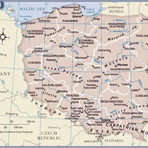
The Eastern Frontier, 1919. Map showing parts of Germany, Prussia, Russia and Austria during the First World War, 1914-1919, with fortified towns and main railway lines indicated. From " The History of the Great European War: its causes and effects", Vol. III, by W. Stanley Macbean Knight. [Caxton Pulishing Company, Limited, London, 1919]
Heritage Images features heritage image collections
Media ID 19047783
© The Print Collector/Heritage Images
Austria Hungary Austro Hungarian Austro Hungarian Empire Baltic Sea Caxton Publishing Company Caxton Pulishing Company Caxton Pulishing Company Lim Caxton Pulishing Company Limited Caxton Pulishing Company Ltd Eastern Front Frontier Knight Limited London Geographical Institute Poland Prussia Stanley Macbean Stanley Macbean Knight Theatre Of War W Stanley Macbean W Stanley Macbean Knight William Stanley Macbean William Stanley Macbean Knight
12"x10" Modern Frame
Step back in time with our exquisite framed print from the Media Storehouse collection, featuring a captivating historical map from Heritage Images. Titled "The Eastern Frontier, 1919," this stunning piece showcases the intricacies of the geopolitical landscape during the First World War. Created by the renowned London Geographical Institute, this map meticulously details fortified towns and major railway lines across Germany, Prussia, Russia, and Austria. A perfect addition to any home office, library, or history enthusiast's collection, this framed print is a testament to the rich historical depth of the past. Bring the story of the Eastern Frontier to life in your home today.
10x8 Print in an MDF Wooden Frame with 180 gsm Satin Finish Paper. Glazed using shatter proof thin plexi glass. Frame thickness is 1 inch and depth 0.75 inch. Fluted cardboard backing held with clips. Supplied ready to hang with sawtooth hanger and rubber bumpers. Spot clean with a damp cloth. Packaged foam wrapped in a card.
Contemporary Framed and Mounted Prints - Professionally Made and Ready to Hang
Estimated Image Size (if not cropped) is 25.4cm x 25.4cm (10" x 10")
Estimated Product Size is 25.4cm x 30.5cm (10" x 12")
These are individually made so all sizes are approximate
Artwork printed orientated as per the preview above, with landscape (horizontal) or portrait (vertical) orientation to match the source image.
FEATURES IN THESE COLLECTIONS
> Arts
> Artists
> C
> William Caxton
> Europe
> Austria
> Related Images
> Europe
> Hungary
> Related Images
The Eastern Frontier, 1919 - A Historical Snapshot of Europe's Turbulent Past
EDITORS COMMENTS
. This print captures a map titled "The Eastern Frontier, 1919" created by the esteemed London Geographical Institute. The map provides a fascinating glimpse into the complex geopolitical landscape during the First World War (1914-1919). Highlighted on this meticulously detailed map are parts of Germany, Prussia, Russia, and Austria - countries that played pivotal roles in shaping the outcome of this devastating conflict. Fortified towns and main railway lines are also indicated, offering valuable insights into strategic military positions and transportation networks. Originally featured in W. Stanley Macbean Knight's renowned publication "The History of the Great European War: its causes and effects". Volume III, this historical artifact offers an invaluable resource for understanding one of humanity's darkest chapters. As we explore this image further, we can't help but be drawn to its vibrant colors that bring life to an era long gone. Its significance lies not only in its depiction of borders and territories but also as a testament to human resilience amidst chaos. Let us delve into history through this visual time capsule – a reminder of how nations once stood divided yet interconnected along the Eastern Front. It serves as a poignant reminder that our shared past shapes our present reality while urging us to learn from it so that we may build a more peaceful future.
MADE IN THE USA
Safe Shipping with 30 Day Money Back Guarantee
FREE PERSONALISATION*
We are proud to offer a range of customisation features including Personalised Captions, Color Filters and Picture Zoom Tools
SECURE PAYMENTS
We happily accept a wide range of payment options so you can pay for the things you need in the way that is most convenient for you
* Options may vary by product and licensing agreement. Zoomed Pictures can be adjusted in the Cart.