Framed Print > Arts > Artists > I > Indian School Indian School
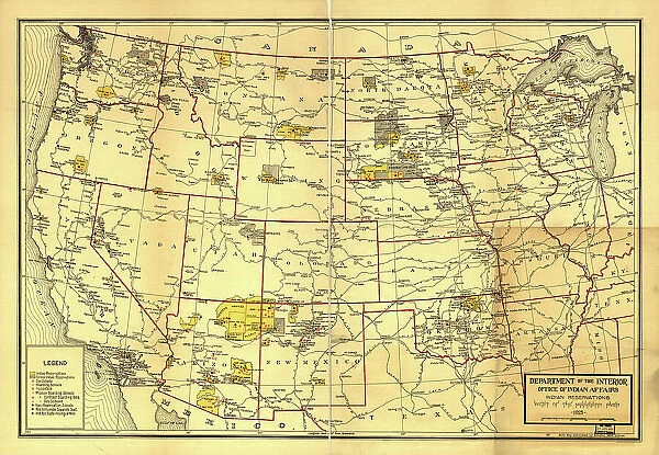
Framed Print : Indian Reservations west of the Mississippi River, 1923. Creator: Office of Indian Affairs
![]()

Framed Photos from Heritage Images
Indian Reservations west of the Mississippi River, 1923. Creator: Office of Indian Affairs
Indian Reservations west of the Mississippi River, 1923. This map, created by the Office of Indian Affairs in 1923, shows the location of Indian reservations west of the Mississippi River. The names of the tribes are given and important geographic features such as state boundaries and rivers and railways are shown. Reservation schools and hospitals are also marked. In 1924, Congress passed the Indian Citizenship Act, which granted citizenship rights to Native Americans
Heritage Images features heritage image collections
Media ID 35130271
© Heritage Art/Heritage Images
Boundary Cartographic Cartography Citizenship Department Of The Interior Government Hospital Indians Legend Map Making Mapmaking Mississippi Mississippi River North America North American Reservation River Mississippi School Tribe Us Government Meeting Of Frontiers Tribes
18"x14" Modern Frame
Step back in time with our captivating Framed Prints from the Media Storehouse collection. This vintage map, created by the Office of Indian Affairs in 1923, offers a unique glimpse into history with its depiction of Indian reservations west of the Mississippi River. The intricate details and authenticity of this black and white image will transport you to a bygone era. Add this historical piece to your home or office decor and start a conversation about the rich history of the American West.
16x12 Print in an MDF Wooden Frame with 180 gsm Satin Finish Paper. Glazed using shatter proof thin plexiglass. Frame thickness is 1 inch and depth 0.75 inch. Fluted cardboard backing held with clips. Supplied ready to hang with sawtooth hanger and rubber bumpers. Spot clean with a damp cloth. Packaged foam wrapped in a card.
Contemporary Framed and Mounted Prints - Professionally Made and Ready to Hang
Estimated Image Size (if not cropped) is 40.6cm x 35.6cm (16" x 14")
Estimated Product Size is 45.7cm x 35.6cm (18" x 14")
These are individually made so all sizes are approximate
Artwork printed orientated as per the preview above, with landscape (horizontal) orientation to match the source image.
FEATURES IN THESE COLLECTIONS
> Arts
> Artists
> I
> Indian School Indian School
> Maps and Charts
> Early Maps
> Maps and Charts
> Related Images
> North America
> United States of America
> Maps
> North America
> United States of America
> Mississippi
> Related Images
> Popular Themes
> Railway Posters
EDITORS COMMENTS
This map, created by the Office of Indian Affairs in 1923, offers a glimpse into the geography and demography of Indian reservations west of the Mississippi River during the 1920s. The map meticulously marks the names of various Native American tribes, providing a testament to their rich cultural heritage. Important geographic features, such as state boundaries, rivers, and railways, are delineated, offering context to the reservation locations. The map also highlights the presence of reservation schools and hospitals, reflecting the ongoing efforts to provide education and healthcare services to Native American communities. This map holds significant historical importance, as it was produced just a year before the Indian Citizenship Act was passed by Congress in 1924, granting citizenship rights to Native Americans. The map serves as a visual representation of the meeting of frontiers, where the boundaries of Native American territories intersected with the expanding United States. The map's intricate details, including the use of color to distinguish different tribes and the clear labeling of reservation schools and hospitals, make it an essential resource for understanding the complex history of Native American communities in North America during the 20th century. This map, with its wealth of information, invites us to explore the rich history of the United States and the indigenous peoples who have shaped its heritage.
MADE IN THE USA
Safe Shipping with 30 Day Money Back Guarantee
FREE PERSONALISATION*
We are proud to offer a range of customisation features including Personalised Captions, Color Filters and Picture Zoom Tools
SECURE PAYMENTS
We happily accept a wide range of payment options so you can pay for the things you need in the way that is most convenient for you
* Options may vary by product and licensing agreement. Zoomed Pictures can be adjusted in the Cart.


