Framed Print > Europe > United Kingdom > Scotland > Maps
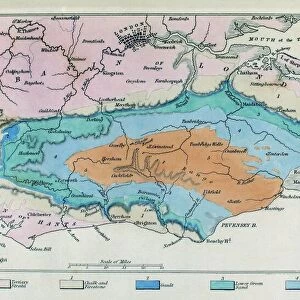
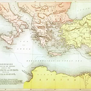
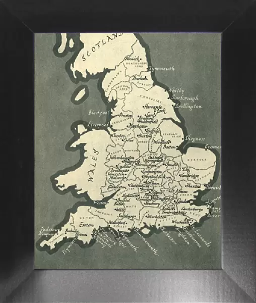
Framed Print : Map of England, with principal towns and cities, 1943. Creator: F Nichols


![]()
Framed Photos from Heritage Images
Map of England, with principal towns and cities, 1943. Creator: F Nichols
Map of England, with principal towns and cities, 1943. Places Mentioned in the Text. From " English Cities and Small Towns", by John Betjeman. [Collins, London, 1943]
Heritage Images features heritage image collections
Media ID 19781095
© The Print Collector/Heritage Images
Bamp W Betjeman Britain In Pictures Coastline Collins John Betjeman Nichols Sir John Betjeman Social History Wales William Collins William Collins And Sons William Collins Sons
12"x10" Modern Frame
Step back in time with our vintage Framed Print of a Map of England, as it appeared in 1943. This charming piece, created by F Nichols and originally featured in John Betjeman's "English Cities and Small Towns" publication by Collins, London, showcases the principal towns and cities of England during that era. A perfect addition to any home office, library, or nostalgia-filled space, this framed print transports you to a bygone era, making it a unique and intriguing conversation starter. Embrace the classic charm and historical significance of this vintage map, now available in our Media Storehouse collection.
10x8 Print in an MDF Wooden Frame with 180 gsm Satin Finish Paper. Glazed using shatter proof thin plexi glass. Frame thickness is 1 inch and depth 0.75 inch. Fluted cardboard backing held with clips. Supplied ready to hang with sawtooth hanger and rubber bumpers. Spot clean with a damp cloth. Packaged foam wrapped in a card.
Contemporary Framed and Mounted Prints - Professionally Made and Ready to Hang
Estimated Image Size (if not cropped) is 25.4cm x 25.4cm (10" x 10")
Estimated Product Size is 25.4cm x 30.5cm (10" x 12")
These are individually made so all sizes are approximate
Artwork printed orientated as per the preview above, with landscape (horizontal) or portrait (vertical) orientation to match the source image.
FEATURES IN THESE COLLECTIONS
> Animals
> Mammals
> Muridae
> Fortior
> Arts
> Artists
> C
> William Collins
> Arts
> Artists
> S
> William Small
> Arts
> Artists
> W
> John White
> Arts
> Artists
> W
> William White
> Europe
> United Kingdom
> England
> Maps
> Europe
> United Kingdom
> Scotland
> Maps
> Europe
> United Kingdom
> Scotland
> Posters
> Europe
> United Kingdom
> Scotland
> Related Images
> Europe
> United Kingdom
> Wales
> Maps
EDITORS COMMENTS
This print showcases a Map of England from 1943, highlighting the principal towns and cities during that era. Created by F Nichols, this map is featured in "English Cities and Small Towns" written by the renowned John Betjeman. The map provides an insightful glimpse into the geography and social history of Britain in the mid-20th century. The intricate details on this print allow us to explore the coastal regions, towns, and cities across England. From Wales to Scotland, every significant location is meticulously marked, offering a comprehensive understanding of British geography during that time period. As we delve into this historical artifact, it becomes evident that William Collins played a crucial role in preserving such valuable pieces of British heritage. This particular map was published under their banner as part of their esteemed series called "Britain in Pictures". Sir John Betjeman's contribution adds another layer of significance to this print. Known for his profound love for English architecture and culture, Betjeman's writings have become iconic representations of British identity. Overall, this print serves as both a visual delight and an educational resource for those interested in exploring Britain's past. It encapsulates not only the physical landscape but also offers insights into societal structures prevalent at that time. A true treasure for history enthusiasts!
MADE IN THE USA
Safe Shipping with 30 Day Money Back Guarantee
FREE PERSONALISATION*
We are proud to offer a range of customisation features including Personalised Captions, Color Filters and Picture Zoom Tools
SECURE PAYMENTS
We happily accept a wide range of payment options so you can pay for the things you need in the way that is most convenient for you
* Options may vary by product and licensing agreement. Zoomed Pictures can be adjusted in the Cart.