Framed Print > Africa > Egypt > Maps
Framed Print : Map of the Turkish attack on the Suez Canal, Egypt, First World War, 1915, (c1920)
")
")

![]()
Framed Photos from Heritage Images
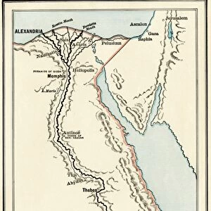
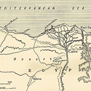
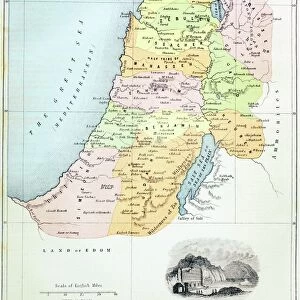
Map of the Turkish attack on the Suez Canal, Egypt, First World War, 1915, (c1920)
Map of the Turkish attack on the Suez Canal, Egypt, First World War, 1915, (c1920). Map showing approximately the direction of the Turkish Attack on the Suez Canal, January 25 - February 3, 1915. From " The Great World War - A History" Volume II, edited by Frank A Mumby. [The Gresham Publishing Company Ltd, London, c1920]
Heritage Images features heritage image collections
Media ID 19175269
© The Print Collector/Heritage Images
Attack Desert Frank Arthur Frank Arthur Mumby Front Line Frontline Gresham Publishing Co Ltd Gresham Publishing Company Israel Keystone Archives Mediterranean Sea Mumby Mumby Frank Arthur Nile North Africa Port Said River Nile Sinai Sinai Egypt Suez Canal The Great World War A History The Nile Theatre Of War Turkey Turkish Battlefield Gaza Gulf Of Suez
18"x14" Modern Frame
Step back in time with our vintage Framed Print from the Media Storehouse collection. This intriguing map, hailing from the First World War era, depicts the Turkish attack on the Suez Canal in Egypt during January 25 - February 3, 1915. The map, sourced from Heritage Images and created around 1920, offers a unique historical perspective. Display this captivating piece in your home or office to add character and conversation-starting intrigue. The high-quality print is expertly framed to preserve its vintage charm and protect against damage, making it a beautiful and educational addition to any space.
16x12 Print in an MDF Wooden Frame with 180 gsm Satin Finish Paper. Glazed using shatter proof thin plexiglass. Frame thickness is 1 inch and depth 0.75 inch. Fluted cardboard backing held with clips. Supplied ready to hang with sawtooth hanger and rubber bumpers. Spot clean with a damp cloth. Packaged foam wrapped in a card.
Contemporary Framed and Mounted Prints - Professionally Made and Ready to Hang
Estimated Image Size (if not cropped) is 40.6cm x 35.6cm (16" x 14")
Estimated Product Size is 45.7cm x 35.6cm (18" x 14")
These are individually made so all sizes are approximate
Artwork printed orientated as per the preview above, with landscape (horizontal) orientation to match the source image.
FEATURES IN THESE COLLECTIONS
> Africa
> Egypt
> Related Images
> Animals
> Mammals
> Muridae
> Desert Mouse
> Asia
> Israel
> Related Images
> Asia
> Palestine
> Related Images
> Asia
> Turkey
> Related Images
EDITORS COMMENTS
This print showcases a historical map titled "Map of the Turkish attack on the Suez Canal, Egypt, First World War, 1915". The map, dating back to approximately 1920, depicts the direction of the Turkish assault on the Suez Canal between January 25th and February 3rd in 1915. From "The Great World War - A History". Volume II edited by Frank A Mumby, this map offers a glimpse into one of the significant events that unfolded during World War I. It provides valuable insight into the strategic movements and geographical features surrounding this pivotal battleground. The image captures not only an important moment in history but also highlights various elements such as Africa's coastlines, deserts like Sinai in Egypt, and key locations including Port Said and Gaza Palestine Israel. The Suez Canal itself is prominently featured alongside other notable landmarks like the River Nile and Gulf of Suez. With its detailed representation of military operations during this period of conflict, this photograph serves as a reminder of the bravery displayed by armed forces fighting along these front lines. It symbolizes both the devastating impact war can have on nations while also showcasing their resilience. Preserved by The Print Collector from Keystone Archives under unknown authorship or commercial use restrictions, this image invites viewers to delve deeper into our shared history through exploration and appreciation for those who fought bravely during World War I.
MADE IN THE USA
Safe Shipping with 30 Day Money Back Guarantee
FREE PERSONALISATION*
We are proud to offer a range of customisation features including Personalised Captions, Color Filters and Picture Zoom Tools
SECURE PAYMENTS
We happily accept a wide range of payment options so you can pay for the things you need in the way that is most convenient for you
* Options may vary by product and licensing agreement. Zoomed Pictures can be adjusted in the Cart.