Framed Print > Europe > United Kingdom > England > London > Towns > Church End
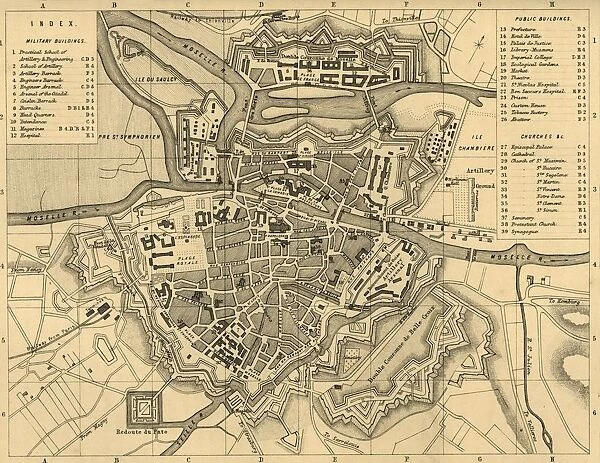
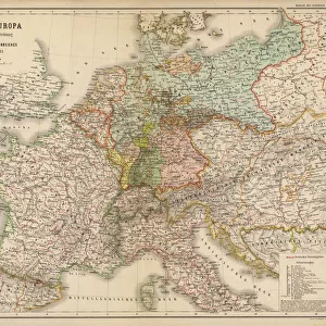
Framed Print : Plan of Metz and its Fortifications, c1872. Creator: R. Walker
![]()

Framed Photos from Heritage Images
Plan of Metz and its Fortifications, c1872. Creator: R. Walker
Plan of Metz and its Fortifications, c1872. Map of the town of Metz (in France), showing military buildings, public buildings, churches etc. The Siege of Metz (19 August-27 October 1870) during the Franco-Prussian War, ended in a decisive Allied German victory. From " The Franco-Prussian War: its causes, incidents and consequences", Volume I, by Captain H M Hozier. [William Mackenzie, London, 1872]
Heritage Images features heritage image collections
Media ID 19778889
© The Print Collector/Heritage Images
1870 1871 Bamp W Fortified Franco Prussian War H M Hozier Henry Montague Henry Montague Hozier Hozier Lorraine Mackenzie Metz Mosel Moselle R Walker River Mosel Robert Walker Sir Henry Montagu Hozier Walker William Mackenzie Fortifications Siege Of Metz
12"x10" Modern Frame
Step back in time with our stunning Framed Print of "Plan of Metz and its Fortifications, c1872" from the Media Storehouse collection. This captivating map, created by R. Walker, offers a unique glimpse into the past, showcasing the military and public buildings, churches, and fortifications of Metz, France. Transport yourself to the 19th century and adorn your walls with this intriguing piece of historical cartography. Perfect for history enthusiasts, scholars, or anyone seeking to add a touch of timeless charm to their decor.
10x8 Print in an MDF Wooden Frame with 180 gsm Satin Finish Paper. Glazed using shatter proof thin plexi glass. Frame thickness is 1 inch and depth 0.75 inch. Fluted cardboard backing held with clips. Supplied ready to hang with sawtooth hanger and rubber bumpers. Spot clean with a damp cloth. Packaged foam wrapped in a card.
Contemporary Framed and Mounted Prints - Professionally Made and Ready to Hang
Estimated Image Size (if not cropped) is 25.4cm x 25.4cm (10" x 10")
Estimated Product Size is 30.5cm x 25.4cm (12" x 10")
These are individually made so all sizes are approximate
Artwork printed orientated as per the preview above, with landscape (horizontal) or portrait (vertical) orientation to match the source image.
FEATURES IN THESE COLLECTIONS
> Arts
> Artists
> W
> Robert Walker
> Arts
> Artists
> W
> Robert White
> Arts
> Artists
> W
> William White
> Europe
> France
> Canton
> Moselle
> Europe
> United Kingdom
> England
> London
> Towns
> Church End
EDITORS COMMENTS
This print showcases the "Plan of Metz and its Fortifications, c1872", created by R. Walker. The detailed map depicts the town of Metz in France, highlighting military buildings, public structures, churches, and more. It serves as a historical record of the city's layout during a significant period in its history. The photograph holds immense historical value due to its connection with the Siege of Metz during the Franco-Prussian War from 19 August to 27 October 1870. This conflict ultimately resulted in a resounding victory for Allied Germany forces. The image is sourced from Captain H M Hozier's renowned publication "The Franco-Prussian War: its causes, incidents and consequences". Volume I. Metz's fortified walls are prominently featured in this print, emphasizing their strategic importance during wartime. The river Mosel gracefully winds through the cityscape, adding an element of natural beauty amidst these man-made fortifications. Through this photograph, viewers can gain insight into the geographical features that shaped Metz in the late nineteenth century. The meticulous attention to detail allows us to appreciate Robert Walker's skillful cartography work while providing valuable information about this historic location. Preserved by William Mackenzie Publishing House in London back in 1872, this print stands as a testament to both artistic craftsmanship and historical documentation. Its existence offers us a glimpse into an era defined by conflict and transformation – reminding us of our collective past and inspiring further exploration into
MADE IN THE USA
Safe Shipping with 30 Day Money Back Guarantee
FREE PERSONALISATION*
We are proud to offer a range of customisation features including Personalised Captions, Color Filters and Picture Zoom Tools
SECURE PAYMENTS
We happily accept a wide range of payment options so you can pay for the things you need in the way that is most convenient for you
* Options may vary by product and licensing agreement. Zoomed Pictures can be adjusted in the Cart.


