Framed Print > Architecture > Bridges > Tower Bridge
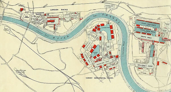
Framed Print : Port of London Authority - Map, 1937. Creator: Unknown
![]()

Framed Photos from Heritage Images
Port of London Authority - Map, 1937. Creator: Unknown
Port of London Authority - Map, 1937. The River Thames in London, showing Tower Bridge, the Tower of London, St Katharine Docks, Western and Eastern Docks, West India Docks, Blackwall Basin, Upper and Lower Pools, Fenchurch St. Leman St. Shadwell, Stepney, West India Dock and Millwall Junction stations, Limehouse Reach, Regent's Canal Dock, Shadwell New Basin, West India Docks, Poplar Docks, Millwall Dock, Surrey Commercial Docks: Lavender, Stave, Island, Albion, Lady, Russia, Quebec, Canada, Norway, Greenland and South Docks. From "The Said Noble River", by Alan Bell. [The Port of London Authority, London, 1937]
Heritage Images features heritage image collections
Media ID 36240956
© The Print Collector/Heritage Images
Alan Bell Bell Alan Dock Docklands Docklands Tower Hamlets London England Docks Export Import London Docklands London England United Kingdom Quay West India Docks West India Quay Wharf Importation West India Dock Road
18"x14" Modern Frame
Step back in time with our vintage 'Port of London Authority - Map' Framed Print from Media Storehouse. This beautifully preserved image, dating back to 1937, offers a captivating glimpse into the rich maritime history of London. Witness the iconic sights of the River Thames, including Tower Bridge, the Tower of London, St Katharine Docks, and various other historic docks. The intricate details of this map, created by an unknown artist, are brought to life in our high-quality framed print. Add a touch of history and character to your home or office decor with this unique piece from Heritage Images.
16x12 Print in an MDF Wooden Frame with 180 gsm Satin Finish Paper. Glazed using shatter proof thin plexiglass. Frame thickness is 1 inch and depth 0.75 inch. Fluted cardboard backing held with clips. Supplied ready to hang with sawtooth hanger and rubber bumpers. Spot clean with a damp cloth. Packaged foam wrapped in a card.
Contemporary Framed and Mounted Prints - Professionally Made and Ready to Hang
Estimated Image Size (if not cropped) is 40.6cm x 35.6cm (16" x 14")
Estimated Product Size is 45.7cm x 35.6cm (18" x 14")
These are individually made so all sizes are approximate
Artwork printed orientated as per the preview above, with landscape (horizontal) orientation to match the source image.
FEATURES IN THESE COLLECTIONS
> Architecture
> Bridges
> Tower Bridge
> Architecture
> Towers
> Tower Bridge
> Architecture
> Towers
> Tower of London
> Asia
> India
> Related Images
> Europe
> Norway
> Related Images
EDITORS COMMENTS
This map print, titled 'Port of London Authority - Map' and dated 1937, offers a fascinating glimpse into the bustling maritime landscape of London during the 1930s. Created by an unknown artist, this colorful and detailed representation of the River Thames showcases the vast network of docks and wharves that once dominated the city's eastern waterfront. The map stretches from Tower Bridge and the Tower of London in the west, to Millwall Dock and Surrey Commercial Docks in the east. Notable features include St Katharine Docks, Western and Eastern Docks, West India Docks, Blackwall Basin, Upper and Lower Pools, and various other docks named after countries such as Norway, Canada, and Russia. The map also highlights various stations along the waterfront, including Fenchurch St. Leman St. Shadwell, Stepney, West India Dock and Millwall Junction. The intricate network of roads and quays leading to the docks is also depicted, providing a sense of the complex logistical infrastructure that facilitated the import and export of goods. This map, originally published in Alan Bell's book 'The Said Noble River', is a testament to the rich maritime history of London and the vital role it played in global trade during the 20th century. The intricate details and vibrant colors bring the past to life, offering a captivating window into a bygone era.
MADE IN THE USA
Safe Shipping with 30 Day Money Back Guarantee
FREE PERSONALISATION*
We are proud to offer a range of customisation features including Personalised Captions, Color Filters and Picture Zoom Tools
SECURE PAYMENTS
We happily accept a wide range of payment options so you can pay for the things you need in the way that is most convenient for you
* Options may vary by product and licensing agreement. Zoomed Pictures can be adjusted in the Cart.


