Framed Print > Animals > Mammals > Muridae > Desert Mouse
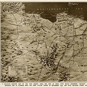
Framed Print : Relief Map of Sahara Algerien, 1914. Creator: Unknown


![]()
Framed Photos from Heritage Images
Relief Map of Sahara Algerien, 1914. Creator: Unknown
Relief Map of Sahara Algerien, 1914. From "Grande Geographie Bong Illustree", 1914
Heritage Images features heritage image collections
Media ID 36294533
© The Print Collector/Heritage Images
Algeria Africa Cartography Colonies Colony Desert Map Making Mapmaking Mediterranean Sea North Africa North African Sahara Sahara Desert Africa Relief Map
12"x10" Modern Frame
Discover the mysteries of the Sahara Desert with our vintage Relief Map of Sahara Algerien, dating back to 1914. This unique framed print, sourced from Heritage Images, showcases intricate topographical details of the Algerian region of the Sahara, making it a captivating addition to any home or office. With its antique charm, this map transports you back in time, offering a glimpse into the exploration and cartography of the past. Unknown creator adds to its enigmatic allure. Bring history to life with this stunning framed print from Media Storehouse.
10x8 Print in an MDF Wooden Frame with 180 gsm Satin Finish Paper. Glazed using shatter proof thin plexi glass. Frame thickness is 1 inch and depth 0.75 inch. Fluted cardboard backing held with clips. Supplied ready to hang with sawtooth hanger and rubber bumpers. Spot clean with a damp cloth. Packaged foam wrapped in a card.
Contemporary Framed and Mounted Prints - Professionally Made and Ready to Hang
Estimated Image Size (if not cropped) is 25.4cm x 25.4cm (10" x 10")
Estimated Product Size is 25.4cm x 30.5cm (10" x 12")
These are individually made so all sizes are approximate
Artwork printed orientated as per the preview above, with landscape (horizontal) or portrait (vertical) orientation to match the source image.
FEATURES IN THESE COLLECTIONS
> Africa
> Algeria
> Related Images
> Animals
> Mammals
> Muridae
> Desert Mouse
> Maps and Charts
> Related Images
EDITORS COMMENTS
This Relief Map of Sahara Algerien, created in 1914, offers a fascinating glimpse into the colonial era's cartographic exploration of North Africa. The map, published in "Grande Geographie Bong Illustree," showcases the intricate topography of the Sahara Desert in Algeria, a region that was then under French colonial rule. The map's vibrant colors and intricate engravings bring the desert landscape to life, with mountain ranges, valleys, and oases meticulously depicted. The Mediterranean Sea is also prominently featured, highlighting the strategic importance of this region as a colonial powerbase. The map's title, "Sahara Algerien," emphasizes the focus on Algeria within the larger context of the Sahara Desert. This map is a testament to the advancements in cartography during the 20th century and the European colonial powers' drive to explore and claim new territories. The map's creation during the 1910s, a period of intense colonial activity, underscores the significance of this map in understanding the geopolitical landscape of the time. Despite its unknown creator, this Relief Map of Sahara Algerien remains an essential historical document, providing valuable insights into the geography and colonial history of North Africa. Its intricate details and stunning visual appeal continue to captivate viewers and scholars alike, making it a prized addition to any collection focused on cartography, colonialism, or African studies.
MADE IN THE USA
Safe Shipping with 30 Day Money Back Guarantee
FREE PERSONALISATION*
We are proud to offer a range of customisation features including Personalised Captions, Color Filters and Picture Zoom Tools
SECURE PAYMENTS
We happily accept a wide range of payment options so you can pay for the things you need in the way that is most convenient for you
* Options may vary by product and licensing agreement. Zoomed Pictures can be adjusted in the Cart.