Framed Print > Historic England > Heritage > Objects and Artefacts
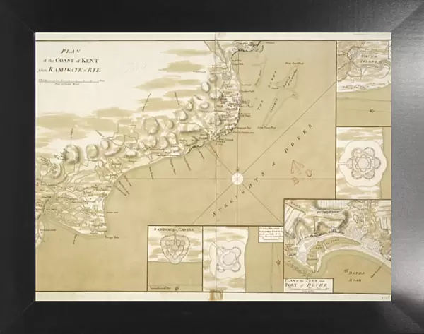
Framed Print : Kent coastal defences in 1740 J010166


![]()
Framed Photos from Historic England
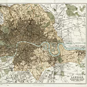
Kent coastal defences in 1740 J010166
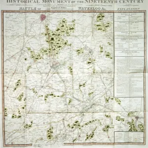
WALMER CASTLE, Kent. " Plan of the coast of Kent from Ramsgate to Rye" 1740. Chart of the approaches to the Kent coast showing details of the coastal defences at Sandwich, Deal, Dover, Walmer and Sandgate. Map
Historic England is the public body that champions and protects England's historic places
Media ID 5240362
© Historic England
18"x14" Modern Frame
Introducing the captivating Framed Print from Media Storehouse, featuring an intriguing image of "Kent coastal defences in 1740" (J010166) by Historic England Photo Library. This exquisite print showcases a detailed chart of the approaches to the Kent coast, highlighting the defensive structures at Sandwich, Deal, and Dover. Travel back in time with this historical masterpiece and add a touch of nostalgia to your home or office decor. The high-quality print is expertly framed, ensuring a stunning presentation that is sure to impress. Embrace the rich history of England with this unique and captivating piece.
16x12 Print in an MDF Wooden Frame with 180 gsm Satin Finish Paper. Glazed using shatter proof thin plexiglass. Frame thickness is 1 inch and depth 0.75 inch. Fluted cardboard backing held with clips. Supplied ready to hang with sawtooth hanger and rubber bumpers. Spot clean with a damp cloth. Packaged foam wrapped in a card.
Contemporary Framed and Mounted Prints - Professionally Made and Ready to Hang
Estimated Image Size (if not cropped) is 40.6cm x 35.6cm (16" x 14")
Estimated Product Size is 45.7cm x 35.6cm (18" x 14")
These are individually made so all sizes are approximate
Artwork printed orientated as per the preview above, with landscape (horizontal) orientation to match the source image.
FEATURES IN THESE COLLECTIONS
> England at War
> Defending the Coast
> Heritage
> Objects and Artefacts
EDITORS COMMENTS
This print takes us back to the year 1740, offering a glimpse into the coastal defences of Kent during the Georgian era. Titled "Kent Coastal Defences in 1740 J010166" this historic artifact showcases a meticulously detailed plan of the coast from Ramsgate to Rye. The chart provides invaluable insights into the strategic locations and intricate fortifications that safeguarded Sandwich, Deal, Dover, Walmer, and Sandgate. As we delve into this snapshot from history, we are transported to an era where protection against potential invasions was paramount. The map reveals an array of defensive structures dotting the coastline - bastions standing tall like sentinels guarding their territories. Each stronghold is carefully marked with precision on this remarkable document. The image emanates a sense of awe as we contemplate how these coastal defences played a crucial role in safeguarding Kent's shores centuries ago. It serves as a testament to human ingenuity and determination in protecting their land from external threats. Preserved by Historic England Photo Library, this print not only captures our attention but also invites us to reflect upon our rich heritage and appreciate those who came before us. It reminds us that history is not merely confined within textbooks; it lives through artifacts like these – windows into forgotten worlds waiting for curious minds to explore them once again.
MADE IN THE USA
Safe Shipping with 30 Day Money Back Guarantee
FREE PERSONALISATION*
We are proud to offer a range of customisation features including Personalised Captions, Color Filters and Picture Zoom Tools
SECURE PAYMENTS
We happily accept a wide range of payment options so you can pay for the things you need in the way that is most convenient for you
* Options may vary by product and licensing agreement. Zoomed Pictures can be adjusted in the Cart.