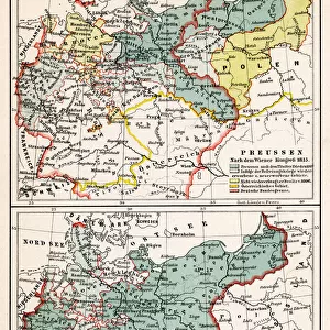
Framed Print : 1799, Cary Map of Prussia and Lithuania, John Cary, 1754 - 1835, was an English cartographer


![]()
Framed Photos from Liszt Collection
1799, Cary Map of Prussia and Lithuania, John Cary, 1754 - 1835, was an English cartographer
1799, Cary Map of Prussia and Lithuania, John Cary, 1754 - 1835, was an English cartographer, John Cary, 1754 - 1835, English cartographer
Liszt Collection of nineteenth-century engravings and images to browse and enjoy
Media ID 14006893
© Artokoloro Quint Lox Limited
1754 1835 1754 – 1835 17541835 1799 English Cartographer John Cary Was An English Cartographer Antique Map Latitude Longitude Mappa Mundi Old Antique Plan Old Antique View Ols Antique Map Rare Old Maps Topo
12"x10" Modern Frame
Discover the historical depth of your home decor with the Media Storehouse Framed Print of the 1799 Cary Map of Prussia and Lithuania. This exquisite piece showcases the intricate cartography work of English cartographer John Cary, born in 1754. Dating back to 1799, this antique map offers a captivating glimpse into the geography and political landscape of Prussia and Lithuania during that era. Add a touch of history and sophistication to your space with this beautiful and authentic framed print from the Liszt Collection.
10x8 Print in an MDF Wooden Frame with 180 gsm Satin Finish Paper. Glazed using shatter proof thin plexi glass. Frame thickness is 1 inch and depth 0.75 inch. Fluted cardboard backing held with clips. Supplied ready to hang with sawtooth hanger and rubber bumpers. Spot clean with a damp cloth. Packaged foam wrapped in a card.
Contemporary Framed and Mounted Prints - Professionally Made and Ready to Hang
Estimated Image Size (if not cropped) is 25.4cm x 25.4cm (10" x 10")
Estimated Product Size is 30.5cm x 25.4cm (12" x 10")
These are individually made so all sizes are approximate
Artwork printed orientated as per the preview above, with landscape (horizontal) or portrait (vertical) orientation to match the source image.
EDITORS COMMENTS
This print showcases the remarkable "1799, Cary Map of Prussia and Lithuania" meticulously crafted by the renowned English cartographer, John Cary (1754 - 1835). With a keen eye for detail and precision, Cary's expertise in cartography is beautifully displayed in this vintage piece. The map itself offers an intriguing glimpse into the past, providing a visual representation of the topography, geography, and land features of Prussia and Lithuania during that era. Its intricate illustrations bring to life a world long gone, evoking a sense of nostalgia for history enthusiasts. As one explores this ancient artifact, they are transported back in time through its delicate paper texture and retro aesthetic. The faded colors add to its charm as it exudes an aged yet historic allure. This decorative piece not only serves as a navigational tool but also ignites curiosity about exploration and discovery during those times. It reminds us of how far we have come in terms of geographical knowledge while honoring the artistry involved in creating such maps. A true gem from the Liszt Collection, this rare antique map captures both artistry and historical significance. Whether adorning your study or serving as an educational resource for students interested in old-world cartography, this print is sure to spark conversations about our planet's rich history.
MADE IN THE USA
Safe Shipping with 30 Day Money Back Guarantee
FREE PERSONALISATION*
We are proud to offer a range of customisation features including Personalised Captions, Color Filters and Picture Zoom Tools
SECURE PAYMENTS
We happily accept a wide range of payment options so you can pay for the things you need in the way that is most convenient for you
* Options may vary by product and licensing agreement. Zoomed Pictures can be adjusted in the Cart.