Framed Print > Posters > Vintage
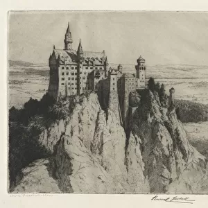
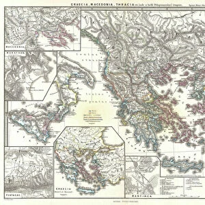
Framed Print : Old Map of the Alps


![]()
Framed Photos from Liszt Collection
Old Map of the Alps
OLD MAP OF THE ALPS
Liszt Collection of nineteenth-century engravings and images to browse and enjoy
Media ID 12980519
© Quint Lox Limited
18"x14" Modern Frame
Discover the captivating history of the Alps with our Old Map of the Alps framed print from the Liszt Collection. This exquisite piece showcases intricate detail and vibrant colors, transporting you back in time to explore the breathtaking landscapes and legendary mountain ranges. The antique map, beautifully framed, adds an elegant touch to any room, making it a perfect addition to your home or office decor. Bring a piece of the past into your present with our Old Map of the Alps framed print.
16x12 Print in an MDF Wooden Frame with 180 gsm Satin Finish Paper. Glazed using shatter proof thin plexiglass. Frame thickness is 1 inch and depth 0.75 inch. Fluted cardboard backing held with clips. Supplied ready to hang with sawtooth hanger and rubber bumpers. Spot clean with a damp cloth. Packaged foam wrapped in a card.
Contemporary Framed and Mounted Prints - Professionally Made and Ready to Hang
Estimated Image Size (if not cropped) is 40.6cm x 35.6cm (16" x 14")
Estimated Product Size is 45.7cm x 35.6cm (18" x 14")
These are individually made so all sizes are approximate
Artwork printed orientated as per the preview above, with landscape (horizontal) orientation to match the source image.
FEATURES IN THESE COLLECTIONS
> Maps and Charts
> Related Images
> Liszt Collection
> Engravings
EDITORS COMMENTS
This print showcases an exquisite "Old Map of the Alps" from the nineteenth century. A true testament to history, this engraved image takes us back in time to a bygone era when explorers and cartographers meticulously crafted detailed maps by hand. The intricate illustrative technique employed in this piece is nothing short of remarkable, with every contour and peak of the majestic Alps expertly depicted. The vintage charm exuded by this retro-styled map transports us to a Victorian age where artistry and culture flourished. Its engravement adds depth and texture, enhancing its allure as a timeless piece of art. As we gaze upon it, we can almost hear echoes of mountaineers' footsteps echoing through these ancient valleys. The Liszt Collection has once again curated a masterpiece that captures our imagination and invites us on a journey through time. This old chart not only serves as an aesthetic delight but also offers valuable insights into the geographical evolution of one Europe's most iconic mountain ranges. Whether displayed in your living room or study, this print will undoubtedly become a conversation starter for those who appreciate both history and artistic craftsmanship. Let yourself be transported to an era long gone while admiring the beauty that lies within this Old Map of the Alps - an extraordinary blend of nostalgia and elegance brought forth by 000035's lens.
MADE IN THE USA
Safe Shipping with 30 Day Money Back Guarantee
FREE PERSONALISATION*
We are proud to offer a range of customisation features including Personalised Captions, Color Filters and Picture Zoom Tools
SECURE PAYMENTS
We happily accept a wide range of payment options so you can pay for the things you need in the way that is most convenient for you
* Options may vary by product and licensing agreement. Zoomed Pictures can be adjusted in the Cart.