Framed Print > Europe > United Kingdom > England > London > Boroughs > Southwark
Framed Print : Southwark SE22 8 Map


![]()
Framed Photos from Map Marketing
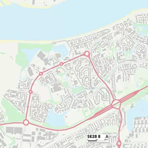
Southwark SE22 8 Map
Postcode Sector Map of Southwark SE22 8
Media ID 19981788
Ashbourne Grove Burrow Road Colwell Road Derwent Grove Highwood Close Jarvis Road Lordship Lane Plough Lane Shaw Road Southwark St Francis Road Talbot Road
12"x10" Modern Frame
10x8 Print in an MDF Wooden Frame with 180 gsm Satin Finish Paper. Glazed using shatter proof thin plexi glass. Frame thickness is 1 inch and depth 0.75 inch. Fluted cardboard backing held with clips. Supplied ready to hang with sawtooth hanger and rubber bumpers. Spot clean with a damp cloth. Packaged foam wrapped in a card.
Contemporary Framed and Mounted Prints - Professionally Made and Ready to Hang
Estimated Image Size (if not cropped) is 25.4cm x 25.4cm (10" x 10")
Estimated Product Size is 30.5cm x 25.4cm (12" x 10")
These are individually made so all sizes are approximate
Artwork printed orientated as per the preview above, with landscape (horizontal) or portrait (vertical) orientation to match the source image.
FEATURES IN THESE COLLECTIONS
> Arts
> Artists
> P
> Francis Place
> Europe
> United Kingdom
> England
> London
> Boroughs
> Southwark
> Maps and Charts
> Related Images
> Popular Themes
> Railway Posters
> Map Marketing
> Postcode Sector Maps
> SE - London SE
MADE IN THE USA
Safe Shipping with 30 Day Money Back Guarantee
FREE PERSONALISATION*
We are proud to offer a range of customisation features including Personalised Captions, Color Filters and Picture Zoom Tools
SECURE PAYMENTS
We happily accept a wide range of payment options so you can pay for the things you need in the way that is most convenient for you
* Options may vary by product and licensing agreement. Zoomed Pictures can be adjusted in the Cart.