Framed Print > Europe > United Kingdom > Northern Ireland > County Down > Newcastle
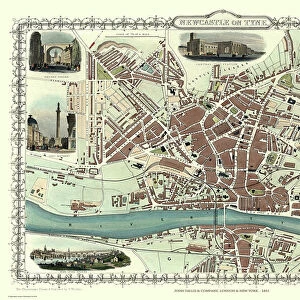
Framed Print : Old Map of Newcastle upon Tyne and Gateshead 1808 by Cole and Roper


![]()
Framed Photos from MapSeeker
Old Map of Newcastle upon Tyne and Gateshead 1808 by Cole and Roper
An attractive and detailed early 19th century reproduction town plan of Newcastle upon Tyne and Gateshead 1808. First published by Cole and Roper as a finely engraved series of county maps and town plans which were initially issued in parts and then together as The British Atlas in 1810
Welcome to the Mapseeker Image library and enter an historic gateway to one of the largest on-line collections of Historic Maps, Nostalgic Views, Vista's and Panorama's from a World gone by.
Media ID 20348124
© Mapseeker Publishing Ltd
Cole And Roper Historic Map Old Town Plan Gateshead Newcastle Newcastle On Tyne Newcastle Upon Tyne
12"x10" Modern Frame
Step back in time with our stunning Framed Print of the Old Map of Newcastle upon Tyne and Gateshead 1808 by Cole and Roper from MapSeeker. This attractive reproduction showcases an intricately detailed town plan of Newcastle upon Tyne and Gateshead, first published in the early 19th century. The finely engraved map by Cole and Roper transports you back to a bygone era, making it an excellent addition to any home or office. With its rich historical significance, this framed print is not just a decorative piece, but also a conversation starter and a reminder of the fascinating history of Newcastle and Gateshead.
10x8 Print in an MDF Wooden Frame with 180 gsm Satin Finish Paper. Glazed using shatter proof thin plexi glass. Frame thickness is 1 inch and depth 0.75 inch. Fluted cardboard backing held with clips. Supplied ready to hang with sawtooth hanger and rubber bumpers. Spot clean with a damp cloth. Packaged foam wrapped in a card.
Contemporary Framed and Mounted Prints - Professionally Made and Ready to Hang
Estimated Image Size (if not cropped) is 25.4cm x 25.4cm (10" x 10")
Estimated Product Size is 30.5cm x 25.4cm (12" x 10")
These are individually made so all sizes are approximate
Artwork printed orientated as per the preview above, with landscape (horizontal) or portrait (vertical) orientation to match the source image.
FEATURES IN THESE COLLECTIONS
> Arts
> Photorealistic artworks
> Detailed art pieces
> Masterful detailing in art
> Europe
> United Kingdom
> Northern Ireland
> County Down
> Newcastle
> Maps and Charts
> Early Maps
> MapSeeker
> British Town And City Plans
> English & Welsh PORTFOLIO
EDITORS COMMENTS
This print showcases an exquisite reproduction of the "Old Map of Newcastle upon Tyne and Gateshead 1808" by Cole and Roper. Dating back to the early 19th century, this town plan offers a fascinating glimpse into the historical landscape of Newcastle upon Tyne and its neighboring town, Gateshead. With intricate details and stunning engravings, this map was originally published as part of a series by Cole and Roper. It provides a comprehensive overview of the county maps and town plans that were meticulously crafted during that era. The British Atlas, in which these maps were eventually compiled in 1810, stands as a testament to their dedication to cartography. As we delve into this historic masterpiece, we are transported back in time to witness the evolution of Newcastle upon Tyne's cityscape. Every street corner, building, and landmark is intricately depicted on this old map—offering us a window into the past. Whether you are an avid history enthusiast or simply curious about how our cities have transformed over time, this print serves as both an educational resource and a beautiful piece of art. Its timeless charm captures the essence of Newcastle's rich heritage while honoring the craftsmanship behind Cole and Roper's work.
MADE IN THE USA
Safe Shipping with 30 Day Money Back Guarantee
FREE PERSONALISATION*
We are proud to offer a range of customisation features including Personalised Captions, Color Filters and Picture Zoom Tools
SECURE PAYMENTS
We happily accept a wide range of payment options so you can pay for the things you need in the way that is most convenient for you
* Options may vary by product and licensing agreement. Zoomed Pictures can be adjusted in the Cart.