Framed Print > Arts > Artists > T > John Tallis
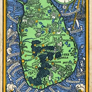
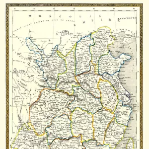
Framed Print : British Ceylon, or Sri Lanka 1851


![]()
Framed Photos from MapSeeker
British Ceylon, or Sri Lanka 1851
A fine facimile artworked from an antique original map of British Ceylon or Sri Lanka, issued as part of the 1851 edition of John Tallis and Companys " The Illustrated Atlas and Modern History of the World"
Welcome to the Mapseeker Image library and enter an historic gateway to one of the largest on-line collections of Historic Maps, Nostalgic Views, Vista's and Panorama's from a World gone by.
Media ID 20347652
© Mapseeker Publishing Ltd
John Tallis John Tallis Map Tallis Map Polynesia Sri Lanka
18"x14" Modern Frame
Step back in time with our exquisite framed print of "British Ceylon, or Sri Lanka 1851" by John Tallis and John Rapkin from MapSeeker. This beautiful facsimile artwork is meticulously crafted from an antique original map, taken from the renowned 1851 edition of John Tallis and Company's "The Illustrated Atlas." Immerse yourself in history as you display this captivating piece in your home or office. With intricate details and rich colors, this framed print is not only a decorative addition but also a conversation starter. Bring a piece of the past into your present with our authentic reproduction of this classic map of Sri Lanka.
16x12 Print in an MDF Wooden Frame with 180 gsm Satin Finish Paper. Glazed using shatter proof thin plexiglass. Frame thickness is 1 inch and depth 0.75 inch. Fluted cardboard backing held with clips. Supplied ready to hang with sawtooth hanger and rubber bumpers. Spot clean with a damp cloth. Packaged foam wrapped in a card.
Contemporary Framed and Mounted Prints - Professionally Made and Ready to Hang
Estimated Image Size (if not cropped) is 35.6cm x 40.6cm (14" x 16")
Estimated Product Size is 35.6cm x 45.7cm (14" x 18")
These are individually made so all sizes are approximate
Artwork printed orientated as per the preview above, with portrait (vertical) orientation to match the source image.
FEATURES IN THESE COLLECTIONS
> Arts
> Artists
> T
> John Tallis
> Asia
> Sri Lanka
> Related Images
> Maps and Charts
> Popular Maps
> Maps and Charts
> Related Images
> Maps and Charts
> World
> MapSeeker
> Maps of Asia and Middle East
> Maps of Countries in Asia PORTFOLIO
EDITORS COMMENTS
This exquisite print showcases a remarkable piece of history - an antique original map of British Ceylon, or Sri Lanka as it is known today. The map was originally issued in 1851 as part of John Tallis and Company's renowned "The Illustrated Atlas and Modern History of the World". With intricate details and stunning craftsmanship, this fine facsimile artwork faithfully captures the essence of the original map. It takes us back to a time when British influence shaped the landscape and culture of Ceylon. As we gaze upon this old Polynesia map, we are transported to a bygone era filled with exploration and discovery. The names of cities, rivers, mountains, and regions evoke a sense of mystery and wonder about this tropical paradise. John Tallis' expertise in cartography shines through every line drawn on this historic document. His collaboration with John Rapkin brings forth an artistic masterpiece that not only serves as a navigational tool but also tells stories from centuries past. Whether you have an affinity for maps or simply appreciate artistry rooted in historical significance, this print will surely captivate your imagination. It offers a glimpse into the rich heritage of Sri Lanka while honoring the legacy left behind by talented individuals like John Tallis and John Rapkin.
MADE IN THE USA
Safe Shipping with 30 Day Money Back Guarantee
FREE PERSONALISATION*
We are proud to offer a range of customisation features including Personalised Captions, Color Filters and Picture Zoom Tools
SECURE PAYMENTS
We happily accept a wide range of payment options so you can pay for the things you need in the way that is most convenient for you
* Options may vary by product and licensing agreement. Zoomed Pictures can be adjusted in the Cart.