Framed Print > Arts > Artists > H > Jodocus Hondius
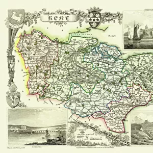
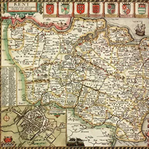
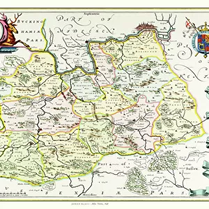
Framed Print : Old County Map of Kent 1648 by Johan Blaeu from the Atlas Novus


![]()
Framed Photos from MapSeeker
Old County Map of Kent 1648 by Johan Blaeu from the Atlas Novus
This detailed and most attractive reproduction map of Kent has been carefully art worked from a scan of an antique original. The famous firm of Dutch cartographers and publishers was established in the late 16th century by Willem Janszoon Blaeu in Amsterdam. Blaeu was a maker of globes and scientific instruments and purchased some of his early map plates from Jodocus Hondius. From this small beginning was to emerge one of the largest and most prolific map publishing houses of the seventeenth century
Welcome to the Mapseeker Image library and enter an historic gateway to one of the largest on-line collections of Historic Maps, Nostalgic Views, Vista's and Panorama's from a World gone by.
Media ID 20347826
Blaeu Blaeu Family Blaue Map County Map County Map Of England English County Map Historic Map Johan Blaeu Johan Blaeu Map Old Blaue Map Old County Map Old English County Map
18"x14" Modern Frame
Discover the rich history of Kent with our exquisite Framed Print of the Old County Map of Kent 1648 by Johan Blaeu from Atlas Novus. This stunning reproduction map, sourced from MapSeeker, showcases intricate details of the county's topography and geography as it appeared over 300 years ago. Carefully art-worked from a high-resolution scan of an original antique map, each print is meticulously framed to preserve its vintage charm and beauty. Bring a piece of historical cartography into your home or office and transport yourself back in time with this impressive and captivating addition to your decor.
16x12 Print in an MDF Wooden Frame with 180 gsm Satin Finish Paper. Glazed using shatter proof thin plexiglass. Frame thickness is 1 inch and depth 0.75 inch. Fluted cardboard backing held with clips. Supplied ready to hang with sawtooth hanger and rubber bumpers. Spot clean with a damp cloth. Packaged foam wrapped in a card.
Contemporary Framed and Mounted Prints - Professionally Made and Ready to Hang
Estimated Image Size (if not cropped) is 40.6cm x 35.6cm (16" x 14")
Estimated Product Size is 45.7cm x 35.6cm (18" x 14")
These are individually made so all sizes are approximate
Artwork printed orientated as per the preview above, with landscape (horizontal) orientation to match the source image.
FEATURES IN THESE COLLECTIONS
> Arts
> Artists
> B
> Willem Blaeu
> Arts
> Artists
> H
> Jodocus Hondius
> Arts
> Photorealistic artworks
> Detailed art pieces
> Masterful detailing in art
> Europe
> United Kingdom
> England
> Kent
> Related Images
> Europe
> United Kingdom
> England
> Maps
> Maps and Charts
> Early Maps
> Maps and Charts
> Willem Janszoon Blaeu
> MapSeeker
> Maps from the British Isles
> England and Counties PORTFOLIO
EDITORS COMMENTS
This exquisite print showcases the "Old County Map of Kent 1648" by Johan Blaeu, a renowned Dutch cartographer and publisher. Carefully reproduced from an antique original, this highly detailed map offers a captivating glimpse into the historical geography of Kent. Johan Blaeu's firm, established in Amsterdam during the late 16th century, quickly gained recognition for its exceptional craftsmanship in creating globes and scientific instruments. The acquisition of map plates from Jodocus Hondius marked the beginning of what would become one of the largest and most prolific map publishing houses of the seventeenth century. The beauty and accuracy captured in this reproduction make it a true collector's item for history enthusiasts. Its intricate artistry transports viewers back to a time when maps were meticulously hand-drawn with utmost precision. Kent, known for its rich heritage and picturesque landscapes, is beautifully depicted on this historic map. Every contour line and landmark has been faithfully preserved to offer an authentic representation of the county as it existed centuries ago. Whether you are an avid collector or simply fascinated by historical cartography, this Old County Map of Kent is sure to captivate your imagination. Displaying it proudly will not only add elegance to any space but also serve as a testament to our enduring fascination with exploring and understanding our past.
MADE IN THE USA
Safe Shipping with 30 Day Money Back Guarantee
FREE PERSONALISATION*
We are proud to offer a range of customisation features including Personalised Captions, Color Filters and Picture Zoom Tools
SECURE PAYMENTS
We happily accept a wide range of payment options so you can pay for the things you need in the way that is most convenient for you
* Options may vary by product and licensing agreement. Zoomed Pictures can be adjusted in the Basket.