Framed Print > Europe > United Kingdom > Scotland > Scottish Borders > Selkirk
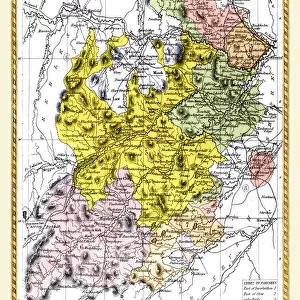
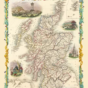
Framed Print : Old Map of the County of Selkirk from the Philips Handy Atlas of 1882


![]()
Framed Photos from MapSeeker
Old Map of the County of Selkirk from the Philips Handy Atlas of 1882
PHA028
Welcome to the Mapseeker Image library and enter an historic gateway to one of the largest on-line collections of Historic Maps, Nostalgic Views, Vista's and Panorama's from a World gone by.
Media ID 20348191
County Map County Map Of Scotland Historic Map Old County Map Old Scottish County Map Scottish County Map Selkirk
12"x10" Modern Frame
Step back in time with our exquisite Framed Prints from Media Storehouse. This particular piece features an Old Map of the County of Selkirk from the Philips Handy Atlas of 1882 (PHA028), obtained exclusively from MapSeeker. The intricate details of the map are beautifully preserved, transporting you back over a century ago. Each print is expertly framed with care, ensuring a stunning presentation that adds character and history to any room in your home or office. Bring a piece of the past into your present with our Framed Prints from Media Storehouse.
10x8 Print in an MDF Wooden Frame with 180 gsm Satin Finish Paper. Glazed using shatter proof thin plexi glass. Frame thickness is 1 inch and depth 0.75 inch. Fluted cardboard backing held with clips. Supplied ready to hang with sawtooth hanger and rubber bumpers. Spot clean with a damp cloth. Packaged foam wrapped in a card.
Contemporary Framed and Mounted Prints - Professionally Made and Ready to Hang
Estimated Image Size (if not cropped) is 25.4cm x 25.4cm (10" x 10")
Estimated Product Size is 25.4cm x 30.5cm (10" x 12")
These are individually made so all sizes are approximate
Artwork printed orientated as per the preview above, with landscape (horizontal) or portrait (vertical) orientation to match the source image.
FEATURES IN THESE COLLECTIONS
> Europe
> United Kingdom
> Scotland
> Maps
> Europe
> United Kingdom
> Scotland
> Scottish Borders
> Selkirk
> Maps and Charts
> Early Maps
> MapSeeker
> Maps from the British Isles
> Scotland and Counties PORTFOLIO
EDITORS COMMENTS
This print showcases an exquisite piece of history - the Old Map of the County of Selkirk from the Philips Handy Atlas of 1882 (PHA028). With its intricate details and rich colors, this old Scottish county map takes us on a journey back in time to explore the enchanting region of Selkirk. As we gaze upon this vintage treasure, we are transported to a bygone era when cartography was both an art form and a scientific endeavor. The careful craftsmanship evident in every line and symbol reminds us of the meticulous efforts that went into creating maps before modern technology took over. The historic significance of this map cannot be overstated. It offers a glimpse into how Selkirk County appeared more than a century ago, providing valuable insights into its geographical features, towns, villages, rivers, and roads. This visual representation allows us to connect with our ancestors who once traversed these lands. Whether you have ancestral ties to Selkirk or simply appreciate historical cartography, this print is sure to captivate your imagination. Hang it proudly on your wall as a testament to Scotland's rich heritage and as a conversation starter for all those who visit your home
MADE IN THE USA
Safe Shipping with 30 Day Money Back Guarantee
FREE PERSONALISATION*
We are proud to offer a range of customisation features including Personalised Captions, Color Filters and Picture Zoom Tools
SECURE PAYMENTS
We happily accept a wide range of payment options so you can pay for the things you need in the way that is most convenient for you
* Options may vary by product and licensing agreement. Zoomed Pictures can be adjusted in the Cart.