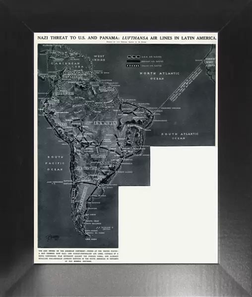
Framed Print : Lufthansa airlines in Latin America by G. H. Davis


![]()
Framed Photos from Mary Evans Picture Library
Lufthansa airlines in Latin America by G. H. Davis
German threat to America and Panama: Lufthansa airlines in Latin America. A map showing how German-controlled airlines, capable of a converging war movement against the Panama Canal, were rivalling Pan-American Airways services in South America during the Second World War. Date: 1941
Mary Evans Picture Library makes available wonderful images created for people to enjoy over the centuries
Media ID 14125619
© Illustrated London News Ltd/Mary Evans
1941 Airlines Airways Argentina Atlantic Brazil Canal Chile Colombia Control Cuba Davis Indies Latin Lufthansa Maps Pacific Panam Panama Paraguay Patagonia Peru Rival Rivalry Route Routes Services Threat Venezuela
12"x10" Modern Frame
Introducing the stunning Framed Print from Media Storehouse's exclusive collection, featuring the captivating work "Lufthansa airlines in Latin America" by G.H. Davis. This vintage image, sourced from Mary Evans Prints Online, paints a historical picture of a time when German-controlled airlines posed a potential threat to the United States and the Panama Canal. The intricate detail and rich colors of this print are sure to add an air of sophistication to any space. With its thought-provoking subject matter and timeless aesthetic, this Framed Print is a must-have for history enthusiasts and art collectors alike. Order yours today and bring a piece of the past into your home or office. Please note that this description does not include specific size information, as Media Storehouse offers various framing options to suit different spaces and preferences.
10x8 Print in an MDF Wooden Frame with 180 gsm Satin Finish Paper. Glazed using shatter proof thin plexi glass. Frame thickness is 1 inch and depth 0.75 inch. Fluted cardboard backing held with clips. Supplied ready to hang with sawtooth hanger and rubber bumpers. Spot clean with a damp cloth. Packaged foam wrapped in a card.
Contemporary Framed and Mounted Prints - Professionally Made and Ready to Hang
Estimated Image Size (if not cropped) is 25.4cm x 25.4cm (10" x 10")
Estimated Product Size is 25.4cm x 30.5cm (10" x 12")
These are individually made so all sizes are approximate
Artwork printed orientated as per the preview above, with landscape (horizontal) or portrait (vertical) orientation to match the source image.
EDITORS COMMENTS
This evocative map by G.H. Davis, created in 1941, illustrates the growing German threat to the Americas during World War II through the expansion of Lufthansa airlines in Latin America. The map highlights the extensive network of German-controlled air routes stretching from Brazil to Venezuela, Chile, Argentina, Paraguay, and Peru, encroaching on the territories traditionally served by Pan-American Airways. The Atlantic and Pacific Oceans frame the map, emphasizing the potential for a converging war movement against the Panama Canal, a vital strategic point for maritime trade and military access. The map's title, "German Threat to America and Panama: Lufthansa Airlines in Latin America," underscores the geopolitical significance of these airlines during wartime. Lufthansa's expansion into Latin America not only challenged Pan-American Airways' dominance but also posed a potential military threat as the German air fleet could be used to transport troops, supplies, and intelligence between Europe and the Americas. Countries depicted on the map, including Cuba, Colombia, and the West Indies, were crucial staging grounds for both German and Allied forces during the war. The map's intricate details, such as the various air routes and their connecting cities, provide a fascinating glimpse into the strategic maneuvering of the time. This historical map is a reminder of the complex geopolitical landscape of World War II and the role that airlines played in shaping the course of the conflict. As we reflect on the past, we can appreciate the importance of understanding the interconnectedness of global events and the role that transportation networks, such as airlines, play in shaping our world.
MADE IN THE USA
Safe Shipping with 30 Day Money Back Guarantee
FREE PERSONALISATION*
We are proud to offer a range of customisation features including Personalised Captions, Color Filters and Picture Zoom Tools
SECURE PAYMENTS
We happily accept a wide range of payment options so you can pay for the things you need in the way that is most convenient for you
* Options may vary by product and licensing agreement. Zoomed Pictures can be adjusted in the Cart.