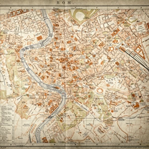
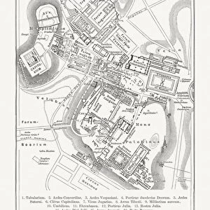
Framed Print : Map of city of Rome. Italian engraving. 16th century


![]()
Framed Photos from Mary Evans Picture Library
Map of city of Rome. Italian engraving. 16th century
Mary Evans Picture Library makes available wonderful images created for people to enjoy over the centuries
Media ID 14337072
© Thaliastock / Mary Evans
1543 Cartography Harbor Haven Mapping Mediterranean
12"x10" Modern Frame
Step back in time with our exquisite Framed Prints from the Media Storehouse collection. This stunning piece showcases a captivating 16th century Italian engraving of the Map of the City of Rome, brought to you by Rights Managed from Mary Evans Prints Online. The intricate details of the ancient city's layout are beautifully preserved in this antique map, transporting you to the heart of Rome during a bygone era. Frame your historical treasure in one of our elegant frames, adding an air of sophistication and timeless charm to your home or office decor.
10x8 Print in an MDF Wooden Frame with 180 gsm Satin Finish Paper. Glazed using shatter proof thin plexi glass. Frame thickness is 1 inch and depth 0.75 inch. Fluted cardboard backing held with clips. Supplied ready to hang with sawtooth hanger and rubber bumpers. Spot clean with a damp cloth. Packaged foam wrapped in a card.
Contemporary Framed and Mounted Prints - Professionally Made and Ready to Hang
Estimated Image Size (if not cropped) is 25.4cm x 25.4cm (10" x 10")
Estimated Product Size is 30.5cm x 25.4cm (12" x 10")
These are individually made so all sizes are approximate
Artwork printed orientated as per the preview above, with landscape (horizontal) or portrait (vertical) orientation to match the source image.
EDITORS COMMENTS
This exquisite 16th century engraving presents a detailed and captivating view of the ancient city of Rome as it appeared during the height of the Renaissance era. Dated to 1543, this Italian masterpiece showcases the city's rich history and cultural significance during a time when cartography was undergoing a revolutionary transformation. The map, meticulously etched onto the parchment, reveals the urban landscape of Rome with an impressive level of accuracy and detail. The Tiber River winds its way through the city, flowing past iconic landmarks such as the Colosseum, Pantheon, and the Vatican City. The harbor and port areas, marked as "Portus" and "Molo," are depicted with ships and boats anchored, reflecting Rome's strategic location on the Mediterranean Sea. The map also highlights the city's cardinal directions, with "North" indicated at the top, and the various districts and neighborhoods are clearly labeled. The intricate detailing of the map's borders and the elegant typography of the inscriptions add to its aesthetic appeal. This engraving is a testament to the advancements in cartography during the Modern Age, as well as a snapshot of Rome's history during the 16th century. It offers a fascinating glimpse into the past, transporting us back to a time when the city was at the center of the European cultural and artistic world.
MADE IN THE USA
Safe Shipping with 30 Day Money Back Guarantee
FREE PERSONALISATION*
We are proud to offer a range of customisation features including Personalised Captions, Color Filters and Picture Zoom Tools
SECURE PAYMENTS
We happily accept a wide range of payment options so you can pay for the things you need in the way that is most convenient for you
* Options may vary by product and licensing agreement. Zoomed Pictures can be adjusted in the Cart.