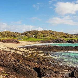
Framed Print > Animals > Birds > Passerines > Finches > Atlantic Canary
Framed Print : Map of the islands in the Atlantic Ocean


![]()
Framed Photos from Mary Evans Picture Library
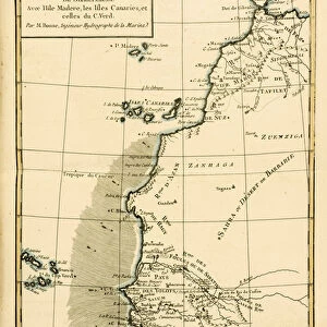
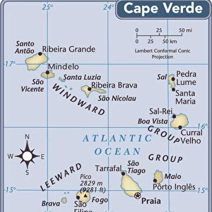
Map of the islands in the Atlantic Ocean
Map of the islands in the Atlantic Ocean -- Azores or Western Isles, Madeira, Bermuda, Canary Islands, Cape Verde. Date: 1851
Mary Evans Picture Library makes available wonderful images created for people to enjoy over the centuries
Media ID 14262775
© Mary Evans / Pharcide
1850s 1851 Atlantic Azores Bermuda Canaries Canary Cape Isle Isles Madeira Maps Verde Bermudas
12"x10" Modern Frame
Discover the rich history and geography of the Atlantic Ocean with our stunning Framed Print of "Map of the Islands in the Atlantic Ocean" from Media Storehouse. This exquisite piece, sourced from Mary Evans Prints Online, dates back to 1851 and showcases intricate detailing of various islands, including the Azores, Madeira, Bermuda, Canary Islands, and Cape Verde. Elevate your home or office decor with this captivating and educational addition. The print comes professionally framed, ready to hang and admire. Let this map transport you on a journey across the Atlantic and inspire wanderlust in you.
10x8 Print in an MDF Wooden Frame with 180 gsm Satin Finish Paper. Glazed using shatter proof thin plexi glass. Frame thickness is 1 inch and depth 0.75 inch. Fluted cardboard backing held with clips. Supplied ready to hang with sawtooth hanger and rubber bumpers. Spot clean with a damp cloth. Packaged foam wrapped in a card.
Contemporary Framed and Mounted Prints - Professionally Made and Ready to Hang
Estimated Image Size (if not cropped) is 25.4cm x 25.4cm (10" x 10")
Estimated Product Size is 25.4cm x 30.5cm (10" x 12")
These are individually made so all sizes are approximate
Artwork printed orientated as per the preview above, with landscape (horizontal) or portrait (vertical) orientation to match the source image.
FEATURES IN THESE COLLECTIONS
> Africa
> Cape Verde
> Maps
> Africa
> Cape Verde
> Related Images
> Animals
> Birds
> Passerines
> Finches
> Atlantic Canary
> Animals
> Mammals
> Muridae
> Water Mouse
> Animals
> Mammals
> Muridae
> Western Mouse
> Arts
> Artists
> O
> Oceanic Oceanic
> Europe
> France
> Canton
> Landes
> Europe
> United Kingdom
> Scotland
> Western Isles
> Related Images
> Maps and Charts
> Related Images
EDITORS COMMENTS
This map print, dated 1851, showcases the islands scattered across the expansive Atlantic Ocean during the Victorian era. The map highlights a collection of mesmerizing islands, including the Azores and Western Isles, Madeira, Bermuda, the Canary Islands, and Cape Verde. Each island is meticulously labeled, providing a glimpse into the rich maritime history of the era. The map's intricate detailing reveals the islands' geographical locations, with the coastlines delicately traced and the surrounding waters teeming with depth soundings and other navigational markers. The map's vibrant colors and ornate cartouche add to its aesthetic appeal, transporting viewers back in time to the 1850s. The Atlantic Ocean, which stretches from the Arctic in the north to the Antarctic in the south, played a significant role in the economic and cultural development of Europe during the Victorian era. This map offers a fascinating glimpse into the maritime world of the time, with its depiction of the various islands that were crucial stops for sailors and explorers traversing the Atlantic. The Azores and Western Isles, located in the mid-Atlantic, were a popular destination for whalers and fishermen, while Madeira, with its lush vineyards, was a prized trading post for European merchants. Bermuda, known for its pink sand beaches, was a popular stop for transatlantic voyages, while the Canary Islands, with their tropical climate and volcanic landscapes, were a popular destination for European settlers. Cape Verde, located off the coast of West Africa, was an important stop for transatlantic slave trade. This map print is a testament to the rich maritime history of the Victorian era and offers a captivating glimpse into the world of exploration and discovery that characterized the time. Its intricate detailing and vibrant colors make it a beautiful addition to any home or office, transporting viewers to a bygone era of adventure and discovery.
MADE IN THE USA
Safe Shipping with 30 Day Money Back Guarantee
FREE PERSONALISATION*
We are proud to offer a range of customisation features including Personalised Captions, Color Filters and Picture Zoom Tools
SECURE PAYMENTS
We happily accept a wide range of payment options so you can pay for the things you need in the way that is most convenient for you
* Options may vary by product and licensing agreement. Zoomed Pictures can be adjusted in the Cart.