Framed Print > Arts > Artists > B > Willem Blaeu
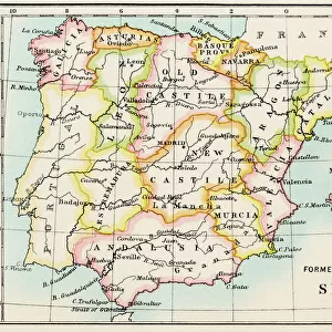
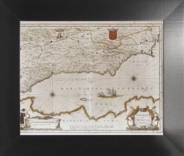
Framed Print : Map of the kingdoms of Granada and Murcia (Granata


![]()
Framed Photos from Mary Evans Picture Library
Map of the kingdoms of Granada and Murcia (Granata
Map of the kingdoms of Granada and Murcia (Granata et Murcia regna) by W. Blaeu. Decorated with the Arms of both States, the figure of a surveyor and a naval combat. Published in Amsterdam, 1635. Engraving. SPAIN. ANDALUSIA. Granada. Tiros House Museum
Mary Evans Picture Library makes available wonderful images created for people to enjoy over the centuries
Media ID 14182552
© J. Bedmar/Iberfoto/Mary Evans
1571 1635 1638 Africans Amsterdam Andalusia Blaeu Combat Craft Engravings Gibraltar Granada Guadalquivir Janszoon Kingdoms Mediterranean Mediterraneans Moroccan Moroccans Morocco Murcia Strait Surveyor Willem
12"x10" Modern Frame
Introducing the captivating addition to your home or office decor - Media Storehouse's Framed Print of "Map of the Kingdoms of Granada and Murcia (Granata et Murcia regna)" by Willem Blaeu. This exquisite map, published in Amsterdam in 1635, offers a historical glimpse into the territories of Granada and Murcia. The intricate details of the map are further enhanced by the inclusion of the Arms of both states, a figure of a surveyor, and a depiction of a naval combat. This beautifully framed print is not only a stunning piece of art but also an educational and cultural addition to any space. Bring history to life with Media Storehouse's Framed Print of "Map of the Kingdoms of Granada and Murcia (Granata et Murcia regna)" by Willem Blaeu.
10x8 Print in an MDF Wooden Frame with 180 gsm Satin Finish Paper. Glazed using shatter proof thin plexi glass. Frame thickness is 1 inch and depth 0.75 inch. Fluted cardboard backing held with clips. Supplied ready to hang with sawtooth hanger and rubber bumpers. Spot clean with a damp cloth. Packaged foam wrapped in a card.
Contemporary Framed and Mounted Prints - Professionally Made and Ready to Hang
Estimated Image Size (if not cropped) is 25.4cm x 25.4cm (10" x 10")
Estimated Product Size is 30.5cm x 25.4cm (12" x 10")
These are individually made so all sizes are approximate
Artwork printed orientated as per the preview above, with landscape (horizontal) or portrait (vertical) orientation to match the source image.
FEATURES IN THESE COLLECTIONS
> Africa
> Morocco
> Related Images
> Africa
> Related Images
> Animals
> Mammals
> Muridae
> House Mouse
> Arts
> Artists
> B
> Willem Blaeu
> Arts
> Landscape paintings
> Waterfall and river artworks
> River artworks
> Maps and Charts
> Willem Janszoon Blaeu
EDITORS COMMENTS
This stunning engraving, titled 'Map of the kingdoms of Granada and Murcia (Granata et Murcia regna)' by Willem Janszoon Blaeu, provides an intricate and detailed representation of the regions of Granada and Murcia in Spain during the early 17th century. The map, published in Amsterdam in 1635, is decorated with the arms of both states and features a surveyor in the top left corner and a naval combat scene in the bottom right. The map covers the southern Spanish provinces of Andalusia, specifically the regions of Granada and Murcia. The intricate detailing of the map includes the winding Guadalquivir River, the Strait of Gibraltar, and the Mediterranean Sea. The map also highlights the African coastline and the Moroccan and African territories, emphasizing the importance of maritime trade and exploration during this period. The inclusion of the arms of both Granada and Murcia adds a sense of historical significance to the map, while the figure of the surveyor and the naval combat scene underscores the importance of cartography and military power in the exploration and colonization of new territories. The map is also adorned with colorful engravings of boats and other maritime craft, further emphasizing the Mediterranean's role as a major hub of trade and transportation during this time. This map was produced by Willem Janszoon Blaeu, a prominent Dutch cartographer and publisher who was active in the late 16th and early 17th centuries. The map is a testament to the advanced cartographic techniques of the time and provides valuable insights into the geography and political landscape of southern Spain during the early modern period.
MADE IN THE USA
Safe Shipping with 30 Day Money Back Guarantee
FREE PERSONALISATION*
We are proud to offer a range of customisation features including Personalised Captions, Color Filters and Picture Zoom Tools
SECURE PAYMENTS
We happily accept a wide range of payment options so you can pay for the things you need in the way that is most convenient for you
* Options may vary by product and licensing agreement. Zoomed Pictures can be adjusted in the Cart.