Framed Print > Europe > United Kingdom > England > London > Towns > Paddington
Framed Print : Map of St Marylebone, London


![]()
Framed Photos from Mary Evans Picture Library
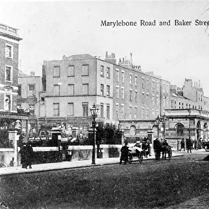
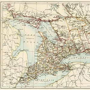
Map of St Marylebone, London
Map of St Marylebone, from a plan of London published by Richard Phillips. Date: 1813
Mary Evans Picture Library makes available wonderful images created for people to enjoy over the centuries
Media ID 14262926
© Mary Evans / Pharcide
1810s 1813 Area Cricket Edgware Georgian Lords Maps Marylebone Oxford Paddington Phillips Plan Soho Tottenham
18"x14" Modern Frame
Discover the charm of historic St Marylebone with our exquisite Framed Print from Media Storehouse. This beautifully detailed map, dated 1813, offers a captivating glimpse into the past, showcasing the streets and landmarks of this London district as they appeared over 200 years ago. Carefully sourced from Mary Evans Prints Online, this Rights Managed print is a must-have for history enthusiasts, interior decorators, and anyone who appreciates the rich history of London. Framed in a classic design, this print adds an air of sophistication and intrigue to any room, making it a perfect addition to your personal or professional space.
16x12 Print in an MDF Wooden Frame with 180 gsm Satin Finish Paper. Glazed using shatter proof thin plexiglass. Frame thickness is 1 inch and depth 0.75 inch. Fluted cardboard backing held with clips. Supplied ready to hang with sawtooth hanger and rubber bumpers. Spot clean with a damp cloth. Packaged foam wrapped in a card.
Contemporary Framed and Mounted Prints - Professionally Made and Ready to Hang
Estimated Image Size (if not cropped) is 40.6cm x 35.6cm (16" x 14")
Estimated Product Size is 45.7cm x 35.6cm (18" x 14")
These are individually made so all sizes are approximate
Artwork printed orientated as per the preview above, with landscape (horizontal) orientation to match the source image.
FEATURES IN THESE COLLECTIONS
> Arts
> Artists
> E
> Richard Evans
> Arts
> Artists
> P
> Richard Phillips
> Arts
> Portraits
> Pop art gallery
> Street art portraits
> Asia
> Georgia
> Related Images
> Europe
> United Kingdom
> England
> London
> Related Images
> Europe
> United Kingdom
> England
> London
> Sport
> Cricket
> Europe
> United Kingdom
> England
> London
> Towns
> Marylebone
> Europe
> United Kingdom
> England
> London
> Towns
> Paddington
> Europe
> United Kingdom
> England
> London
> Towns
> Tottenham
EDITORS COMMENTS
This map print, titled "Map of St Marylebone," dates back to 1813, offering a fascinating glimpse into the streets and roads of London during the Georgian era. Published by renowned cartographer Richard Phillips, this detailed and intricately designed map showcases the layout of St Marylebone, a district located in the heart of London. The map reveals the various roads and streets that crisscrossed St Marylebone in the early 19th century, including Oxford Street, Paddington Street, Edgware Road, and Lords Cricket Ground. The area was known for its elegant townhouses and gardens, with notable landmarks such as Tottenham Court Road, Soho Square, and Lisson Green also featured on the map. The map provides a snapshot of London's urban development during the 1810s, showcasing the expansion of the city beyond its medieval walls. The Georgian architecture that defines much of St Marylebone is evident in the map's meticulous depiction of the district's buildings and structures. The map's antique charm and historical significance make it an invaluable resource for anyone interested in London's history and urban development. It offers a unique perspective into the past, allowing us to explore the streets and roads of St Marylebone as they appeared over 200 years ago.
MADE IN THE USA
Safe Shipping with 30 Day Money Back Guarantee
FREE PERSONALISATION*
We are proud to offer a range of customisation features including Personalised Captions, Color Filters and Picture Zoom Tools
SECURE PAYMENTS
We happily accept a wide range of payment options so you can pay for the things you need in the way that is most convenient for you
* Options may vary by product and licensing agreement. Zoomed Pictures can be adjusted in the Cart.