Framed Print > Asia > India > Maps
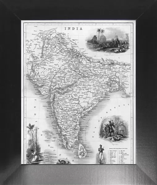
Framed Print : Map / Asia / India C1850


![]()
Framed Photos from Mary Evans Picture Library
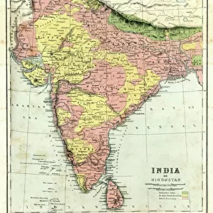
Map / Asia / India C1850
India under British rule, about the time of the Mutiny
Mary Evans Picture Library makes available wonderful images created for people to enjoy over the centuries
Media ID 576626
© Mary Evans Picture Library 2015 - https://copyrighthub.org/s0/hub1/creation/maryevans/MaryEvansPictureID/10015681
12"x10" Modern Frame
Introducing the captivating "Map / Asia / India C1850" framed print from our Media Storehouse collection, brought to you in collaboration with Mary Evans Picture Library from Mary Evans Prints Online. This exquisite piece transports you back in time to the intriguing era of India under British rule, around the time of the Mutiny. The intricate cartographic details of this vintage map beautifully illustrate the geography and political divisions of the Asian subcontinent during the mid-19th century. Enhance your home or office decor with this historically significant and visually stunning addition. Each framed print is carefully crafted with high-quality materials and meticulous attention to detail, ensuring a lasting impression. Experience the allure of the past, as you rediscover history through the lens of this extraordinary map.
10x8 Print in an MDF Wooden Frame with 180 gsm Satin Finish Paper. Glazed using shatter proof thin plexi glass. Frame thickness is 1 inch and depth 0.75 inch. Fluted cardboard backing held with clips. Supplied ready to hang with sawtooth hanger and rubber bumpers. Spot clean with a damp cloth. Packaged foam wrapped in a card.
Contemporary Framed and Mounted Prints - Professionally Made and Ready to Hang
Estimated Image Size (if not cropped) is 25.4cm x 25.4cm (10" x 10")
Estimated Product Size is 25.4cm x 30.5cm (10" x 12")
These are individually made so all sizes are approximate
Artwork printed orientated as per the preview above, with landscape (horizontal) or portrait (vertical) orientation to match the source image.
FEATURES IN THESE COLLECTIONS
> Asia
> India
> Related Images
> Asia
> Related Images
> Maps and Charts
> Early Maps
> Maps and Charts
> India
> Maps and Charts
> Related Images
> Mary Evans Prints Online
> Maps
EDITORS COMMENTS
This print from Mary Evans Picture Library showcases a detailed map of Asia, specifically focusing on India around the year 1850. During this time, India was under British rule, and tensions were rising leading up to the Indian Mutiny.
The map itself is a fascinating glimpse into the past, showing the intricate borders and regions of India as it existed during this pivotal period in history. The level of detail in the map allows viewers to truly immerse themselves in the geography and political landscape of India at that time.
As we study this map, we can't help but reflect on the complex dynamics at play during this era - from colonialism to resistance movements. The presence of British rule looms large over the country, with implications that would shape India's future for generations to come.
Overall, this print serves as a powerful reminder of India's rich history and its struggles for independence. It captures a moment frozen in time when change was on the horizon and revolution was brewing. A true historical treasure that offers valuable insights into one of Asia's most influential nations during a critical juncture in its development.
MADE IN THE USA
Safe Shipping with 30 Day Money Back Guarantee
FREE PERSONALISATION*
We are proud to offer a range of customisation features including Personalised Captions, Color Filters and Picture Zoom Tools
FREE COLORIZATION SERVICE
You can choose advanced AI Colorization for this picture at no extra charge!
SECURE PAYMENTS
We happily accept a wide range of payment options so you can pay for the things you need in the way that is most convenient for you
* Options may vary by product and licensing agreement. Zoomed Pictures can be adjusted in the Cart.