Framed Print > Maps and Charts > British Empire Maps
Framed Print : World Map Empire McVitie


Framed Photos from Mary Evans Picture Library
World Map Empire McVitie
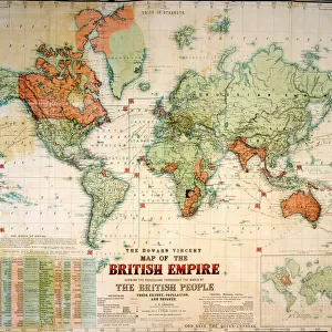
A map of the world, showing the British Empire coloured in red at the end of the nineteenth century
Mary Evans Picture Library makes available wonderful images created for people to enjoy over the centuries
Media ID 592741
© Mary Evans Picture Library 2015 - https://copyrighthub.org/s0/hub1/creation/maryevans/MaryEvansPictureID/10041931
Colonialism Dominions Imperialism Maps Mcvitie Patriotism Power Territory
12"x10" Modern Frame
Discover the rich history and expansive reach of the British Empire with our stunning "World Map Empire McVitie" print from Mary Evans Picture Library. This captivating framed print showcases an intricately detailed map of the world as it appeared at the end of the nineteenth century, with the British Empire's territories vividly depicted in bold red hues. Add an air of sophistication and historical depth to any room with this elegant and thought-provoking piece. The high-quality print is expertly framed and ready to hang, making it a perfect addition to your home or office. Travel back in time and celebrate the legacy of the British Empire with this exquisite framed print.
10x8 Print in an MDF Wooden Frame with 180 gsm Satin Finish Paper. Glazed using shatter proof thin plexi glass. Frame thickness is 1 inch and depth 0.75 inch. Fluted cardboard backing held with clips. Supplied ready to hang with sawtooth hanger and rubber bumpers. Spot clean with a damp cloth. Packaged foam wrapped in a card.
Contemporary Framed and Mounted Prints - Professionally Made and Ready to Hang
Estimated Image Size (if not cropped) is 25.4cm x 20.5cm (10" x 8.1")
Estimated Product Size is 30.5cm x 25.4cm (12" x 10")
These are individually made so all sizes are approximate
Artwork printed orientated as per the preview above, with landscape (horizontal) orientation to match the source image.
FEATURES IN THESE COLLECTIONS
> Maps and Charts
> British Empire Maps
> Maps and Charts
> Early Maps
> Maps and Charts
> Related Images
> Maps and Charts
> World
> Mary Evans Prints Online
> Maps
EDITORS COMMENTS
This striking print of the "World Map Empire McVitie" offers a glimpse into the vast and powerful British Empire at the end of the nineteenth century. The map, colored in bold red to signify British territory, showcases the extent of imperialism and colonialism during this period in history.
The map is a testament to Britain's dominance and influence across the globe, with its various dominions highlighted for all to see. It serves as a reminder of the immense power that Britain held during this time, as well as the impact it had on shaping world events.
As we study this historical artifact, we are transported back to a time when patriotism and national pride were closely tied to notions of empire building and expansion. The map symbolizes not only British strength and authority but also serves as a reflection of global politics and relationships during the late 19th century.
Through examining this map, we gain valuable insights into how historical events have shaped our world today. It is a visual representation of an era marked by ambition, conquest, and territorial control - elements that continue to resonate in our modern society.
Overall, "World Map Empire McVitie" is more than just a geographical depiction; it is a window into an important chapter in human history that continues to inform our understanding of power dynamics and international relations.
MADE IN THE USA
Safe Shipping with 30 Day Money Back Guarantee
FREE PERSONALISATION*
We are proud to offer a range of customisation features including Personalised Captions, Color Filters and Picture Zoom Tools
SECURE PAYMENTS
We happily accept a wide range of payment options so you can pay for the things you need in the way that is most convenient for you
* Options may vary by product and licensing agreement. Zoomed Pictures can be adjusted in the Cart.