Framed Print > Maps and Charts > British Empire Maps
Framed Print : Map of the British Empire


Framed Photos from Mary Evans Picture Library
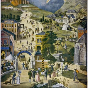
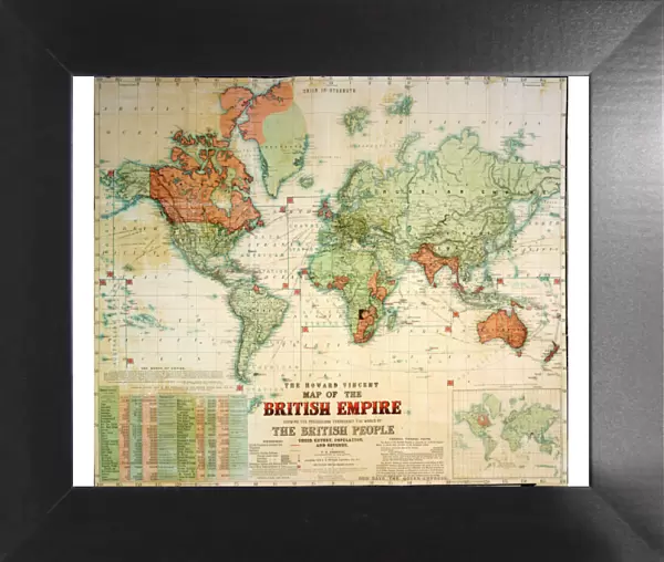
Map of the British Empire
The Howard Vincent map of the British Empire, 1897 Date: 1897
Mary Evans Picture Library makes available wonderful images created for people to enjoy over the centuries
Media ID 7403809
© Mary Evans Picture Library 2015 - https://copyrighthub.org/s0/hub1/creation/maryevans/MaryEvansPictureID/10474597
12"x10" Modern Frame
Introducing the captivating "Map of the British Empire" from our Media Storehouse Framed Prints collection. This vintage masterpiece, dated 1897, is sourced from Mary Evans Prints Online and features the intricate and detailed Howard Vincent map of the British Empire. Bring history into your home or office with this stunning piece, meticulously recreated in a high-quality print and elegantly framed. The rich colors and intricate details of this iconic map are sure to make a statement and spark intrigue. Order now and let this timeless piece transport you to a bygone era.
10x8 Print in an MDF Wooden Frame with 180 gsm Satin Finish Paper. Glazed using shatter proof thin plexi glass. Frame thickness is 1 inch and depth 0.75 inch. Fluted cardboard backing held with clips. Supplied ready to hang with sawtooth hanger and rubber bumpers. Spot clean with a damp cloth. Packaged foam wrapped in a card.
Contemporary Framed and Mounted Prints - Professionally Made and Ready to Hang
Estimated Image Size (if not cropped) is 25.4cm x 22.1cm (10" x 8.7")
Estimated Product Size is 30.5cm x 25.4cm (12" x 10")
These are individually made so all sizes are approximate
Artwork printed orientated as per the preview above, with landscape (horizontal) orientation to match the source image.
FEATURES IN THESE COLLECTIONS
> Maps and Charts
> British Empire Maps
> Maps and Charts
> Popular Maps
> Maps and Charts
> Related Images
> Maps and Charts
> World
> Popular Themes
> Maps and Charts
> Mary Evans Prints Online
> National Archives
EDITORS COMMENTS
This stunning print showcases the intricate and expansive "Map of the British Empire" created by Howard Vincent in 1897. The map, dating back to the 19th century, provides a detailed overview of the vast territories under British rule during this time period.
As we gaze upon this historical artifact, we are transported back to an era when the sun never set on the British Empire. From India to Africa, Australia to Canada, this map illustrates the extent of Britain's global influence and power.
Each line and border on this map tells a story of conquest, colonization, and imperialism. It serves as a reminder of both the achievements and controversies that defined Britain's role as a world superpower in the 19th century.
The meticulous planning and execution required to create such a comprehensive map is evident in every detail. The precision with which each territory is delineated reflects not only geographical accuracy but also political significance.
As we reflect on this piece of history captured in print form by Rights Managed from Mary Evans Prints Online, we are reminded of how maps can serve as powerful tools for understanding our past and shaping our future. This map is not just a representation of landmasses; it is a symbol of ambition, exploration, and legacy that continues to shape our world today.
MADE IN THE USA
Safe Shipping with 30 Day Money Back Guarantee
FREE PERSONALISATION*
We are proud to offer a range of customisation features including Personalised Captions, Color Filters and Picture Zoom Tools
SECURE PAYMENTS
We happily accept a wide range of payment options so you can pay for the things you need in the way that is most convenient for you
* Options may vary by product and licensing agreement. Zoomed Pictures can be adjusted in the Cart.