Framed Print > Europe > United Kingdom > England > London > Transport > Railway
Framed Print : Railway Map of England


![]()
Framed Photos from Mary Evans Picture Library
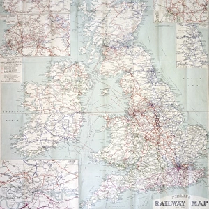
Railway Map of England
London & North Western Railway Co rail map of England, 1899 Date: 1899
Mary Evans Picture Library makes available wonderful images created for people to enjoy over the centuries
Media ID 7402325
© Mary Evans Picture Library 2015 - https://copyrighthub.org/s0/hub1/creation/maryevans/MaryEvansPictureID/10473989
12"x10" Modern Frame
Step back in time with our exquisite Framed Prints from Media Storehouse, featuring this vintage Railway Map of England from the London & North Western Railway Co. Dated 1899, this captivating print showcases intricate details of the railway network during an era of tremendous growth. The Rights Managed image, sourced from Mary Evans Prints Online, is meticulously reproduced and framed to preserve its historical charm. Add this unique piece to your home or office to ignite conversations and transport you back in time. Order now and let the rich history of railways unfold in your space.
10x8 Print in an MDF Wooden Frame with 180 gsm Satin Finish Paper. Glazed using shatter proof thin plexi glass. Frame thickness is 1 inch and depth 0.75 inch. Fluted cardboard backing held with clips. Supplied ready to hang with sawtooth hanger and rubber bumpers. Spot clean with a damp cloth. Packaged foam wrapped in a card.
Contemporary Framed and Mounted Prints - Professionally Made and Ready to Hang
Estimated Image Size (if not cropped) is 25.4cm x 25.4cm (10" x 10")
Estimated Product Size is 25.4cm x 30.5cm (10" x 12")
These are individually made so all sizes are approximate
Artwork printed orientated as per the preview above, with landscape (horizontal) or portrait (vertical) orientation to match the source image.
FEATURES IN THESE COLLECTIONS
> Animals
> Mammals
> Muridae
> Western Mouse
> Europe
> United Kingdom
> England
> London
> Related Images
> Europe
> United Kingdom
> England
> London
> Transport
> Railway
> Europe
> United Kingdom
> England
> Maps
> Europe
> United Kingdom
> England
> Posters
> Europe
> United Kingdom
> England
> Railways
> Maps and Charts
> Related Images
> Popular Themes
> Railway Posters
> Mary Evans Prints Online
> National Archives
EDITORS COMMENTS
This stunning vintage print showcases the intricate Railway Map of England from 1899, specifically highlighting the London & North Western Railway Co rail network. The detailed map provides a fascinating glimpse into the extensive train routes that crisscrossed through England during the 19th century.
The advertisement for this railway company is a true testament to the advancements in transportation and infrastructure during this time period. The carefully drawn lines and labels on the map illustrate just how interconnected England was by rail, allowing for easier travel and trade across the country.
As you study this piece of history, you can't help but marvel at the sheer scale of the English railway system in 1899. It's a reminder of how far we've come in terms of modern transportation and communication networks.
Whether you're a history buff, a train enthusiast, or simply appreciate beautiful vintage prints, this Railway Map of England is sure to captivate your imagination. Let yourself be transported back in time to an era when steam trains ruled the tracks and explore all that this incredible map has to offer.
MADE IN THE USA
Safe Shipping with 30 Day Money Back Guarantee
FREE PERSONALISATION*
We are proud to offer a range of customisation features including Personalised Captions, Color Filters and Picture Zoom Tools
SECURE PAYMENTS
We happily accept a wide range of payment options so you can pay for the things you need in the way that is most convenient for you
* Options may vary by product and licensing agreement. Zoomed Pictures can be adjusted in the Cart.