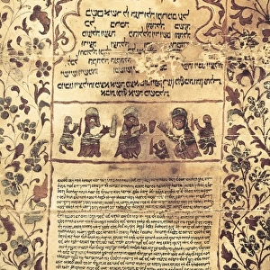
Framed Print : Portolan atlas, 1591. Map of the Arabian Peninsula


![]()
Framed Photos from Mary Evans Picture Library
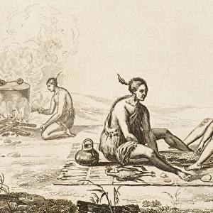
Portolan atlas, 1591. Map of the Arabian Peninsula
Mary Evans Picture Library makes available wonderful images created for people to enjoy over the centuries
Media ID 8271181
© Mary Evans Picture Library 2015 - https://copyrighthub.org/s0/hub1/creation/maryevans/MaryEvansPictureID/10686812
Arabia Arabian Atlas Compass Geographic Geographical Geography Illuminated Islam Islamic Islamics Islamism Islamist Islamists Manuscript Manuscripts Miniatures Muslim Muslims Peninsula Portolan Saudi
12"x10" Modern Frame
Introducing the captivating Portolan Atlas Framed Print from Media Storehouse, showcasing a rare and intriguing map of the Arabian Peninsula, dated 1591. This exquisite antique map, sourced from the esteemed Mary Evans Prints Online, offers a glimpse into the rich history of cartography. The detailed illustrations of ancient cities, coastal outlines, and geographical features transport you back in time, making it an essential addition to any home or office space. Our high-quality framed print is not only a beautiful decor piece but also a thoughtful gift for history enthusiasts and cartography aficionados. Embrace the allure of the past with this stunning Portolan Atlas Framed Print.
10x8 Print in an MDF Wooden Frame with 180 gsm Satin Finish Paper. Glazed using shatter proof thin plexi glass. Frame thickness is 1 inch and depth 0.75 inch. Fluted cardboard backing held with clips. Supplied ready to hang with sawtooth hanger and rubber bumpers. Spot clean with a damp cloth. Packaged foam wrapped in a card.
Contemporary Framed and Mounted Prints - Professionally Made and Ready to Hang
Estimated Image Size (if not cropped) is 25.4cm x 25.4cm (10" x 10")
Estimated Product Size is 25.4cm x 30.5cm (10" x 12")
These are individually made so all sizes are approximate
Artwork printed orientated as per the preview above, with landscape (horizontal) or portrait (vertical) orientation to match the source image.
EDITORS COMMENTS
This stunningly intricate and illuminated map, taken from the Portolan Atlas of 1591, provides a captivating glimpse into the geographical knowledge of the late 16th century. The focus of this particular map is the Arabian Peninsula, a region of great historical, cultural, and religious significance. The map is adorned with vibrant reds and intricate detail, reflecting the meticulous craftsmanship of its creators. The Arabian Peninsula, home to numerous ancient civilizations, is depicted with a high degree of accuracy for the time, considering the challenges of cartography in the pre-modern era. The map includes various features such as the Red Sea, the Gulf of Aden, and the Persian Gulf, as well as major cities and landmarks. The Portolan Atlas, a valuable contribution to the field of cartography, was produced during the height of the Islamic Golden Age, a period marked by significant advancements in science, mathematics, and geography. This map, like many others from the atlas, demonstrates the rich cultural exchange between European and Islamic scholars during this time. The map also features a compass rose, a common navigational tool, further emphasizing the importance of seafaring and exploration during this period. The map serves as a testament to the interconnectedness of the world during the late 16th century and the enduring legacy of Islamic contributions to geographical knowledge.
MADE IN THE USA
Safe Shipping with 30 Day Money Back Guarantee
FREE PERSONALISATION*
We are proud to offer a range of customisation features including Personalised Captions, Color Filters and Picture Zoom Tools
SECURE PAYMENTS
We happily accept a wide range of payment options so you can pay for the things you need in the way that is most convenient for you
* Options may vary by product and licensing agreement. Zoomed Pictures can be adjusted in the Cart.