Framed Print > Historic > Ancient civilizations > Ancient Greece > Greek history
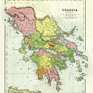
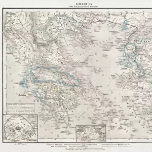
Framed Print : Map of the Peloponnesus of ancient Greece


![]()
Framed Photos from North Wind
Map of the Peloponnesus of ancient Greece
Map of the Peloponnesus of ancient Greece.
Hand-colored woodcut of a 19th-century illustration
North Wind Picture Archives brings history to life with stock images and hand-colored illustrations
Media ID 5878051
© North Wind Picture Archives
Ancient Ancient Civilization Ancient Greece Ancient Greek Ancient History Antiquity Civilization Classical Classical Civilization Europe European Greece Greek Peloponnesus
12"x10" Modern Frame
Discover the rich history of ancient Greece with our exquisitely framed Map of the Peloponnesus print from Media Storehouse and North Wind Picture Archives. This captivating, hand-colored woodcut illustration offers a detailed and captivating view of the Peloponnesus region as it was known in the 19th century. The intricate borders of the frame complement the vintage charm of the map, making it an elegant addition to any home or office. Transport yourself back in time and explore the history, culture, and geography of ancient Greece with this stunning piece.
10x8 Print in an MDF Wooden Frame with 180 gsm Satin Finish Paper. Glazed using shatter proof thin plexi glass. Frame thickness is 1 inch and depth 0.75 inch. Fluted cardboard backing held with clips. Supplied ready to hang with sawtooth hanger and rubber bumpers. Spot clean with a damp cloth. Packaged foam wrapped in a card.
Contemporary Framed and Mounted Prints - Professionally Made and Ready to Hang
Estimated Image Size (if not cropped) is 25.4cm x 25.4cm (10" x 10")
Estimated Product Size is 30.5cm x 25.4cm (12" x 10")
These are individually made so all sizes are approximate
Artwork printed orientated as per the preview above, with landscape (horizontal) or portrait (vertical) orientation to match the source image.
FEATURES IN THESE COLLECTIONS
> Europe
> Greece
> Related Images
> Historic
> Ancient civilizations
> Ancient Greece
> Greek history
> Historic
> Ancient civilizations
> Ancient Greece
> Historic
> Ancient civilizations
> Maps and Charts
> Early Maps
> North Wind Picture Archives
> Ancient history
> North Wind Picture Archives
> Maps
EDITORS COMMENTS
This print showcases a hand-colored woodcut of a 19th-century illustration depicting the Map of the Peloponnesus, an ancient region in Greece. The intricate details and vibrant colors bring to life the rich history and classical beauty of this renowned civilization. The map takes us on a journey through time, back to the days when Greece was at its peak during antiquity. It offers a glimpse into the vast territories that comprised ancient Greece, with particular focus on the Peloponnesus peninsula. This region holds immense historical significance as it was home to some of the most influential city-states such as Sparta and Corinth. Every line and contour on this vintage artwork tells a story about Europe's ancient past. As we explore each corner of this map, we can almost imagine ourselves walking along those ancient roads or sailing across those mythical seas. This piece serves as a reminder of how Greek culture shaped Western civilization as we know it today. From philosophy to art, from democracy to architecture, their contributions have left an indelible mark on humanity. Whether you are an avid historian or simply appreciate artistry from bygone eras, this print is sure to captivate your imagination and transport you back in time to experience firsthand the grandeur and magnificence of Ancient Greece.
MADE IN THE USA
Safe Shipping with 30 Day Money Back Guarantee
FREE PERSONALISATION*
We are proud to offer a range of customisation features including Personalised Captions, Color Filters and Picture Zoom Tools
SECURE PAYMENTS
We happily accept a wide range of payment options so you can pay for the things you need in the way that is most convenient for you
* Options may vary by product and licensing agreement. Zoomed Pictures can be adjusted in the Cart.