Framed Print > North America > Canada > Lakes > Lake Erie
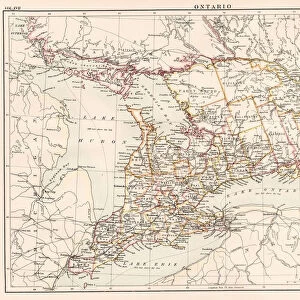
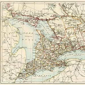
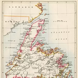
Framed Print : Ontario, 1870s


![]()
Framed Photos from North Wind
Ontario, 1870s
Map of Ontario, Canada, 1870s.
Printed color lithograph
North Wind Picture Archives brings history to life with stock images and hand-colored illustrations
Media ID 5879739
© North Wind Picture Archives
1870s Canada Canadian Great Lakes Lake Erie Lake Ontario Ontario Georgian Bay Lake Huron
18"x14" Modern Frame
Step back in time with our exquisite Framed Print from Media Storehouse, featuring a captivating image of Ontario, Canada from the 1870s. This stunning, printed color lithograph, sourced from the North Wind Picture Archives, offers a glimpse into the past with intricate details and vibrant colors. The vintage map of Ontario perfectly encapsulates the history and charm of the region during this era. Bring this piece of history into your home or office and add an authentic and timeless touch to your decor.
16x12 Print in an MDF Wooden Frame with 180 gsm Satin Finish Paper. Glazed using shatter proof thin plexiglass. Frame thickness is 1 inch and depth 0.75 inch. Fluted cardboard backing held with clips. Supplied ready to hang with sawtooth hanger and rubber bumpers. Spot clean with a damp cloth. Packaged foam wrapped in a card.
Contemporary Framed and Mounted Prints - Professionally Made and Ready to Hang
Estimated Image Size (if not cropped) is 40.6cm x 35.6cm (16" x 14")
Estimated Product Size is 45.7cm x 35.6cm (18" x 14")
These are individually made so all sizes are approximate
Artwork printed orientated as per the preview above, with landscape (horizontal) orientation to match the source image.
FEATURES IN THESE COLLECTIONS
> Asia
> Georgia
> Related Images
> Maps and Charts
> Related Images
> North America
> Canada
> Lakes
> Lake Erie
> North America
> Canada
> Lakes
> Lake Huron
> North America
> Canada
> Lakes
> Lake Ontario
> North America
> Canada
> Lakes
> Related Images
> North America
> Canada
> Maps
> North Wind Picture Archives
> Canadian history
> North Wind Picture Archives
> Maps
EDITORS COMMENTS
This vintage print takes us back to the 1870s, offering a captivating glimpse into the history of Ontario, Canada. The beautifully detailed map showcases the province's vast landscapes and waterways in stunning printed color lithograph. As we explore this piece of art, we are transported to a time when traditional heritage and historic illustrations were valued. The 19th-century illustration highlights Ontario's significant role in Canadian history. It depicts the region's expansive territory, stretching from Lake Erie to Georgian Bay and encompassing iconic landmarks such as Lake Ontario and Lake Huron. These Great Lakes served as vital transportation routes during that era, connecting communities across North America. As we delve deeper into this artwork, it becomes evident that it is more than just a map; it is an artistic representation of Ontario's natural beauty. The attention to detail captures the essence of the province's diverse geography - from rolling hills to dense forests - inviting viewers to appreciate its breathtaking scenery. This print not only serves as a historical artifact but also as a reminder of our connection with nature and our roots. It allows us to reflect on how much has changed since those early days while appreciating the timeless allure of Ontario’s landscape
MADE IN THE USA
Safe Shipping with 30 Day Money Back Guarantee
FREE PERSONALISATION*
We are proud to offer a range of customisation features including Personalised Captions, Color Filters and Picture Zoom Tools
SECURE PAYMENTS
We happily accept a wide range of payment options so you can pay for the things you need in the way that is most convenient for you
* Options may vary by product and licensing agreement. Zoomed Pictures can be adjusted in the Cart.