Framed Print > North Wind Picture Archives > Maps
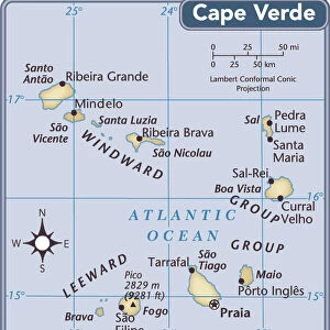
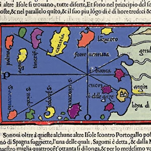
Framed Print : Cape Verde Islands map


![]()
Framed Photos from North Wind
Cape Verde Islands map
Map of the Cape Verde Islands in the Atlantic.
Hand-colored woodcut of a 19th-century illustration
North Wind Picture Archives brings history to life with stock images and hand-colored illustrations
Media ID 5882578
© North Wind Picture Archives
Atlantic Atlantic Ocean Colonial Colony Exploration Maritime Ocean Portuguese Cape Verde Cape Verde Islands Portuguese Colony Saint Vincent
12"x10" Modern Frame
Add a touch of historical charm to your home or office with Media Storehouse's Framed Prints featuring the captivating Cape Verde Islands map from North Wind Picture Archives. This exquisite, hand-colored woodcut illustration dates back to the 19th century, transporting you to a time of exploration and discovery. The intricate details of the map are beautifully preserved within the high-quality frame, making it a stunning conversation starter and a unique addition to any space. Bring the rich history of the Cape Verde Islands into your home today with Media Storehouse's Framed Prints.
10x8 Print in an MDF Wooden Frame with 180 gsm Satin Finish Paper. Glazed using shatter proof thin plexi glass. Frame thickness is 1 inch and depth 0.75 inch. Fluted cardboard backing held with clips. Supplied ready to hang with sawtooth hanger and rubber bumpers. Spot clean with a damp cloth. Packaged foam wrapped in a card.
Contemporary Framed and Mounted Prints - Professionally Made and Ready to Hang
Estimated Image Size (if not cropped) is 25.4cm x 25.4cm (10" x 10")
Estimated Product Size is 30.5cm x 25.4cm (12" x 10")
These are individually made so all sizes are approximate
Artwork printed orientated as per the preview above, with landscape (horizontal) or portrait (vertical) orientation to match the source image.
EDITORS COMMENTS
This vintage print showcases the rich history and maritime heritage of the Cape Verde Islands in the Atlantic Ocean. The hand-colored woodcut, dating back to the 19th century, offers a glimpse into the exploration and colonial era of this Portuguese colony. The map beautifully depicts the archipelago's intricate geography, with its lush landscapes and pristine coastlines. Each stroke of color brings to life the islands' unique charm and cultural significance. From Cape Verde's main island to Saint Vincent, every detail is meticulously portrayed. As we gaze upon this historic illustration, we are transported back in time when seafarers embarked on daring voyages across these vast waters. It serves as a reminder of mankind's relentless pursuit of discovery and adventure. Beyond its aesthetic appeal, this artwork holds immense value for historians and enthusiasts alike who seek to unravel the mysteries that lie within these islands' past. It invites us to delve deeper into their intriguing story – from their early settlement by Portuguese explorers to their role as vital ports along major trade routes. This remarkable piece not only captures an important chapter in our collective history but also celebrates Cape Verde's enduring legacy as a melting pot of cultures influenced by centuries of maritime exchange. Its presence on your wall will undoubtedly spark conversations about art, exploration, and our shared human journey through time.
MADE IN THE USA
Safe Shipping with 30 Day Money Back Guarantee
FREE PERSONALISATION*
We are proud to offer a range of customisation features including Personalised Captions, Color Filters and Picture Zoom Tools
SECURE PAYMENTS
We happily accept a wide range of payment options so you can pay for the things you need in the way that is most convenient for you
* Options may vary by product and licensing agreement. Zoomed Pictures can be adjusted in the Cart.