Framed Print > Europe > United Kingdom > England > Plymouth
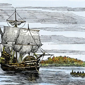
Framed Print : Map of Plymouth Bay, Massachusetts


![]()
Framed Photos from North Wind
Map of Plymouth Bay, Massachusetts
Plymouth Bay on the northern coast of Cape Cod, Massachusetts.
Hand colored woodcut of a 19th-century illustration
North Wind Picture Archives brings history to life with stock images and hand-colored illustrations
Media ID 5882589
© North Wind Picture Archives
Cape Cod Massachusetts New England Plymouth Plymouth Colony Duxbury
12"x10" Modern Frame
Discover the rich history of Plymouth Bay, Massachusetts with this stunning Framed Print from Media Storehouse and North Wind Picture Archives. This exquisite 19th-century hand-colored woodcut illustration transports you back in time, showcasing the picturesque beauty of Plymouth Bay on the northern coast of Cape Cod. Add an elegant touch to your home or office décor while celebrating the heritage of this iconic New England location. Each print is carefully framed with attention to detail, ensuring a museum-quality presentation. Elevate your space with this captivating piece of American history.
10x8 Print in an MDF Wooden Frame with 180 gsm Satin Finish Paper. Glazed using shatter proof thin plexi glass. Frame thickness is 1 inch and depth 0.75 inch. Fluted cardboard backing held with clips. Supplied ready to hang with sawtooth hanger and rubber bumpers. Spot clean with a damp cloth. Packaged foam wrapped in a card.
Contemporary Framed and Mounted Prints - Professionally Made and Ready to Hang
Estimated Image Size (if not cropped) is 25.4cm x 25.4cm (10" x 10")
Estimated Product Size is 25.4cm x 30.5cm (10" x 12")
These are individually made so all sizes are approximate
Artwork printed orientated as per the preview above, with landscape (horizontal) or portrait (vertical) orientation to match the source image.
FEATURES IN THESE COLLECTIONS
> Europe
> United Kingdom
> England
> Maps
> Europe
> United Kingdom
> England
> Plymouth
> North America
> Related Images
> North Wind Picture Archives
> Maps
EDITORS COMMENTS
This print showcases a meticulously hand-colored woodcut of a 19th-century illustration, depicting the Map of Plymouth Bay in Massachusetts. Located on the northern coast of Cape Cod, this historic region holds immense significance as it was here that the iconic Plymouth Colony was established. The map beautifully captures the essence of this heritage-rich area, with its intricate details and vibrant hues. As we delve into this vintage masterpiece, we are transported back in time to an era when exploration and settlement were at their peak. The map not only highlights Plymouth Bay but also encompasses neighboring areas such as Duxbury and Manomet, offering a comprehensive view of this part of New England. With its artistic flair and attention to historical accuracy, this print serves as both a visual delight and an educational tool. It allows us to appreciate the rich history embedded within these lands while providing valuable insights into early American life. Whether you have personal ties to Massachusetts or simply admire American history, this artwork is sure to evoke feelings of nostalgia and curiosity. It stands as a testament to our nation's roots and reminds us of the brave individuals who paved the way for future generations in North America.
MADE IN THE USA
Safe Shipping with 30 Day Money Back Guarantee
FREE PERSONALISATION*
We are proud to offer a range of customisation features including Personalised Captions, Color Filters and Picture Zoom Tools
SECURE PAYMENTS
We happily accept a wide range of payment options so you can pay for the things you need in the way that is most convenient for you
* Options may vary by product and licensing agreement. Zoomed Pictures can be adjusted in the Cart.